
Aerial Imagery Captures Post-Disaster Damage at Tropicana Field
While Hurricane Milton was passing through Florida, significant damage occurred at Tropicana Field, the home stadium of the Tampa Bay Rays. The hurricane’s powerful winds tore apart large sections of the stadium’s roof. Aerial imagery, provided by Vexcel's Gray Sky program, played a critical role in documenting the extent of the damage and assisting in response efforts. This blog will provide an overview of the damage and explain how post-disaster aerial imagery aids recovery efforts.
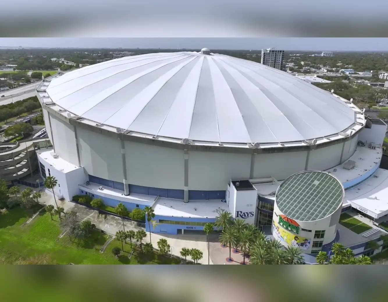
Damage to Tropicana Field After Hurricane Milton
Hurricane Milton struck Florida with winds exceeding 100 mph, causing severe damage to Tropicana Field. The roof, made from PTFE fiberglass fabric, was partially torn off, leaving significant portions of the stadium exposed. The damage interrupted plans to use the stadium as a base camp for emergency responders. Aerial imagery from Vexcel captured the condition of Tropicana Field, providing clear visuals of the roof’s destruction.
Use of Aerial Imagery in Post-Disaster Recovery
Aerial imagery provides essential information in the aftermath of natural disasters. Following Hurricane Milton, Vexcel deployed multiple aircraft to collect high-resolution images over impacted areas, including St. Petersburg, where Tropicana Field is located. These images allow for detailed assessments of structural damage and help emergency responders prioritize resources. For Tropicana Field, aerial imagery enabled engineers and officials to evaluate the extent of the damage without delay, aiding in the planning of necessary repairs.

SkyFi's Role in Providing Disaster Imagery
SkyFi partners with satellite and aerial imagery providers to offer real-time and historical data to government agencies, businesses, and individuals. The platform provides access to post-disaster imagery, allowing users to assess damage quickly and make informed decisions. By accessing data from platforms like Vexcel’s Gray Sky program, SkyFi enables users to obtain aerial images of impacted regions, such as Tropicana Field, for disaster assessment and recovery.
Continuous Collection of Imagery During Hurricane Milton
Throughout Hurricane Milton, Vexcel continued to collect aerial imagery as weather conditions allowed. This included areas along Florida's western coast, such as Tampa, Sarasota, and St. Petersburg. Oblique imagery captured detailed views of structures like Tropicana Field from multiple angles. The imagery was shared with state and local emergency agencies to assist in response and rebuilding efforts.
Aerial Imagery for Broader Applications
While the focus here is on post-disaster recovery, SkyFi and its partners also provide aerial imagery for various other applications, including urban planning, environmental monitoring, and infrastructure management. By making this data readily accessible, SkyFi supports decision-making across multiple industries, ensuring that users have the necessary tools to address diverse challenges.
FAQ Section
Who plays at Tropicana Field? Tropicana Field is home to Major League Baseball's Tampa Bay Rays. The team has played there since its inaugural season in 1998.
What is the Tropicana Field roof made out of? The roof of Tropicana Field is made of PTFE (Polytetrafluoroethylene) fiberglass, a lightweight and durable material designed to withstand harsh weather conditions.
How can aerial imagery help after a disaster? Aerial imagery provides detailed visuals of disaster-affected areas, enabling responders to assess damage to infrastructure, guide resource allocation, and monitor recovery efforts. It is a critical tool in disaster management and recovery planning.
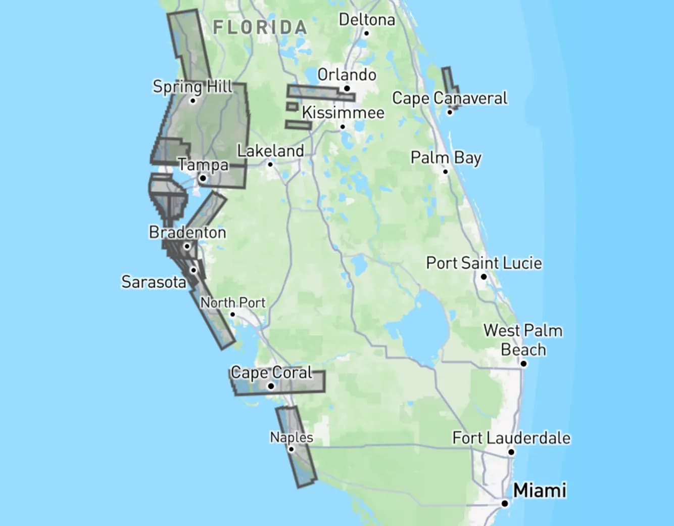
The visual below shows where our platform has post-disaster aerial imagery available.
SkyFi’s platform continues to provide access to aerial imagery for post-disaster assessments and other essential functions. The imagery captured during and after Hurricane Milton offers vital data to support recovery efforts at sites like Tropicana Field and across the affected regions of Florida.


