High-Detail Imagery: Unlocking the Power of Precision
TL;DR (Too Long; Didn’t Read)
High-Detail Imagery provides highly detailed visuals critical for industries such as agriculture, defense, urban planning, and disaster management.
Enhances decision-making by offering precise, actionable insights.
Produced through advanced satellite technology, UAVs, and high-resolution imaging systems.
Applications include environmental monitoring, medical diagnostics, and infrastructure development.
SkyFi’s expertise ensures access to innovative high-detail imagery solutions tailored to diverse needs.
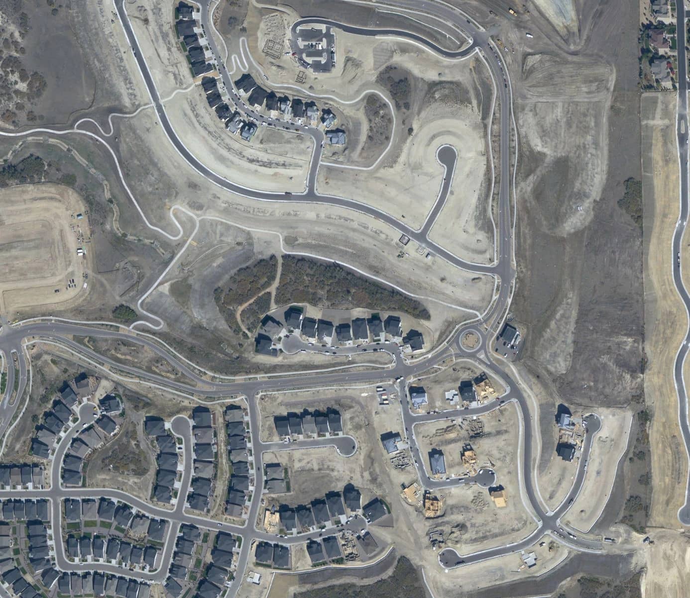
What is High-Detail Imagery?
High-detail imagery is defined as high-resolution visuals captured using advanced imaging technologies, such as satellites, drones, and specialized cameras. This type of imagery is characterized by its exceptional clarity and precision, often measured in terms of pixels per meter or centimeter. Resolutions as fine as 50 cm or better allow for the detection of small details that would otherwise remain hidden in lower-quality images.
This imagery serves as a powerful tool for industries requiring detailed visual data. From satellite constellations capturing global changes to UAVs focusing on localized tasks, high-detail imagery ensures unmatched precision. It enables users to monitor, analyze, and act upon information in ways that drive informed decision-making.
Why is High-Detail Imagery Important?
High-detail imagery plays a pivotal role in enhancing accuracy and insight across industries. Its importance is underscored by its ability to reveal critical information that might otherwise go unnoticed. In agriculture, for instance, high-detail imagery can help farmers detect early signs of crop stress, enabling timely interventions. Disaster response teams use it to assess damage, allocate resources, and plan recovery efforts with unparalleled precision.
The value of high-detail imagery extends to urban planning, where it aids in monitoring infrastructure, tracking development, and managing land use efficiently. Environmental applications include monitoring deforestation and illegal land activities, providing actionable intelligence to stakeholders. By delivering these insights, high-detail imagery ensures better outcomes and more effective resource utilization.
How is High-Detail Imagery Produced?
Producing high-detail imagery involves a combination of advanced technology and sophisticated processes. Satellites equipped with cutting-edge sensors orbit Earth, capturing visuals at resolutions capable of distinguishing objects as small as 50 cm. UAVs and drones complement this by capturing localized imagery, ideal for projects requiring ground-level detail.
Processing is a crucial step in transforming raw data into actionable insights. Advanced techniques like image stitching, resolution enhancement, and spectral analysis refine the captured visuals for specific applications. Platforms such as SkyFi’s Tasking Dashboard simplify this process, allowing users to request, customize, and receive high-resolution imagery efficiently. These systems ensure that imagery is not only precise but also delivered in a user-friendly format.
Applications of High-Detail Imagery
High-detail imagery is indispensable across a wide range of applications. In agriculture, it assists in monitoring crop health, optimizing irrigation, and predicting yields. Urban planners rely on this imagery to map infrastructure, analyze traffic patterns, and manage land use effectively.
Disaster response teams benefit significantly by using before-and-after imagery to assess damage, plan relief efforts, and monitor recovery progress. In forestry, high-detail imagery aids in tracking deforestation, preventing illegal logging, and managing forest health. The medical field leverages it for advanced diagnostics, where detailed visuals are critical for identifying and treating conditions.
How Can High-Detail Imagery Enhance Projects or Research?
High-detail imagery is a transformative tool for projects and research requiring precise data. Its ability to provide actionable insights makes it invaluable for professionals and researchers. For instance, coastal studies benefit from analyzing high-resolution images to track erosion and predict future changes, enabling proactive planning and mitigation strategies.
Businesses also harness the power of high-detail imagery to gain a competitive edge. It can be used to monitor competitors’ supply chains, evaluate asset conditions, or even analyze market trends in near real time. Platforms like SkyFi ensure seamless integration of this data into existing workflows, maximizing efficiency and impact.
Latest Advancements in High-Detail Imaging Technologies
The field of high-detail imagery has witnessed significant advancements in recent years. Modern satellites, such as those operated by SkyFi, now offer resolutions as fine as 50 cm with multiple daily revisits. This capability was once exclusive to government programs but is now accessible to a broader audience.
Artificial intelligence and machine learning have further transformed the industry by automating complex tasks such as object detection and change analysis. These technologies enhance accuracy and speed, reducing the time required for manual interpretation. Additionally, cloud-based platforms have democratized access to high-resolution imagery, allowing organizations of all sizes to leverage cutting-edge geospatial insights.
How Can High-Detail Imagery Be Accessed?
Accessing high-detail imagery has become more convenient than ever. SkyFi’s automated Tasking Dashboard enables users to request specific images by defining areas of interest and setting parameters. The platform provides flexibility, allowing users to obtain fresh images or access extensive archives for historical analysis.
Satellite tasking services offer real-time imagery of specific locations, making them ideal for industries needing immediate insights. Archived imagery, on the other hand, is a cost-effective option for trend analysis and research. By combining these options, platforms like SkyFi deliver tailored solutions to meet diverse requirements.
Challenges Associated with High-Detail Imagery
While high-detail imagery offers immense value, it also presents challenges. One of the primary obstacles is cost, as acquiring and processing high-resolution data requires significant investment. SkyFi addresses this by offering flexible pricing structures to accommodate various budgets.
Data storage and processing also pose technical challenges. The large file sizes associated with high-detail imagery necessitate robust storage systems and powerful processing capabilities. Privacy concerns are another critical issue, particularly when capturing imagery of populated areas. Adherence to ethical guidelines and regulatory compliance ensures responsible data use.
Choosing the Right High-Detail Imagery
Selecting the appropriate high-detail imagery begins with understanding project requirements. Factors such as resolution, data format, and intended application play a crucial role. For example, mapping a dense urban area may require higher resolutions than monitoring agricultural fields.
Platforms like SkyFi simplify the selection process by offering expert guidance and tailored solutions. Users can evaluate service providers based on features, pricing, and support to ensure compatibility with their workflows. By considering these factors, organizations can maximize the value derived from high-detail imagery.
Best Practices for Using High-Detail Imagery Effectively
To use high-detail imagery effectively, clear planning is essential. Defining project objectives and understanding data requirements can streamline the process. Advanced tools and platforms should be leveraged to process and analyze imagery, ensuring that insights are accurate and actionable.
Integrating imagery into workflows can significantly enhance efficiency. APIs, like those offered by SkyFi, allow seamless embedding of imagery into existing systems. Regular updates and consistent monitoring ensure that the data remains relevant and useful throughout the project lifecycle.