Update (October 2025): Maxar Intelligence has officially rebranded as Vantor. All references to “Maxar” in this article now refer to Vantor, which continues to provide the same gold-standard satellite imagery, basemaps, and 3D terrain data trusted worldwide.
Read more about the rebrand: Maxar Rebrands as Vantor and Lanteris — What to Know
TL;DR (Too Long; Didn’t Read)
High-resolution maps provide detailed, accurate visual representations of the Earth.
They are essential tools across industries like urban planning, agriculture, and disaster response.
Created using advanced satellite and aerial imaging, they offer unprecedented clarity.
Accessing these maps is now easier through platforms offering free and paid solutions.
This article explores their creation, benefits, challenges, and future potential.
Defining High-Resolution Maps
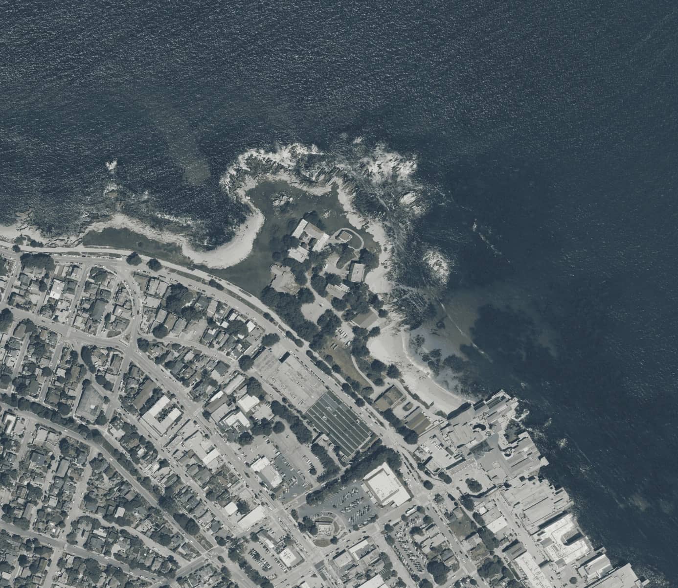
High-resolution maps are detailed visual representations of the Earth's surface created using satellite or aerial imaging technology. The resolution refers to the clarity of the map, typically measured in meters per pixel (m/px). For instance, a resolution of 1m/px means that one pixel on the map represents one meter on the ground. These maps provide significantly more detail than traditional maps, capturing features like streets, vegetation, and even subtle land contours.
The advent of high-resolution mapping technology has revolutionized various industries, allowing users to visualize and analyze data with unmatched accuracy. These maps bridge the gap between generalized geographical overviews and the fine details needed for specialized applications.
Key Features of High-Resolution Maps
High-resolution maps stand out for their ability to seamlessly transition from broad, country-level views to detailed street-level imagery. This scalability is achieved by combining data from various sources, including satellite, aerial, and drone imagery. Platforms like SkyFi offer a unique advantage by integrating data from multiple providers into a cohesive map layer.
Another defining feature is the accuracy of these maps. Resolutions can reach as high as 8cm/px in some regions, revealing intricate details such as building textures, road markings, and vegetation patterns. These maps are constantly updated, ensuring users always have access to the most recent imagery.
Compatibility is another hallmark of high-resolution maps. They can be integrated into web or mobile applications, offering flexibility for industries ranging from urban planning to navigation. Offline self-hosting capabilities further enhance their usability, catering to industries like defense and emergency services.
Benefits of High-Resolution Maps
The applications of high-resolution maps span a broad range of industries and use cases. In urban planning, for instance, these maps provide essential data for designing efficient transportation networks, managing resources, and forecasting population growth. Their ability to capture minute details makes them invaluable for planners working on complex infrastructure projects.
In agriculture, high-resolution maps facilitate precision farming. Farmers can monitor crop health, optimize irrigation, and reduce waste by analyzing the detailed imagery provided by these maps. Similarly, environmental monitoring relies on these maps to track changes in land use, deforestation, and the impacts of natural disasters.
Disaster management teams utilize high-resolution maps for efficient response planning. By providing up-to-date imagery of affected areas, these maps enable rescue teams to allocate resources effectively and prioritize critical zones. Businesses and researchers alike benefit from the cost efficiency of platforms that offer session-based pricing, making high-resolution maps accessible without the burden of excessive costs.
How High-Resolution Maps Are Created
The creation of high-resolution maps involves a combination of satellite imaging, aerial photography, and advanced data processing. Satellites such as those operated by Maxar, Sentinel, and Landsat orbit the Earth, capturing imagery in multiple spectral bands. These bands include visible light, infrared, and radar, providing a comprehensive view of the Earth's surface.
Machine learning algorithms play a crucial role in processing this raw data. They ensure that imagery is clear, consistent, and free of distortions. Drones and aerial platforms further enhance mapping capabilities by capturing localized data that complements satellite imagery. This approach is particularly useful for regions with dense urban development or unique geographical features.
SkyFi leverages these technologies to produce seamless maps that reflect real-world changes. By integrating various data sources, these maps provide a comprehensive view of the Earth with the precision needed for modern applications.
Industries That Rely on High-Resolution Maps
High-resolution maps are indispensable across numerous industries. In transportation, they enable the optimization of logistics and navigation systems. Delivery companies, for instance, use these maps to identify the most efficient routes, saving time and fuel costs.
The real estate industry relies on high-resolution maps for evaluating land use and assessing property potential. These maps provide developers and investors with detailed insights into geographic and infrastructural factors that influence land value.
Emergency response teams use high-resolution maps to coordinate disaster recovery efforts. The ability to analyze detailed imagery of affected areas allows for efficient planning and resource allocation. Government agencies also leverage these maps for national security, infrastructure development, and environmental monitoring.
Challenges in Accessing High-Resolution Maps
While high-resolution maps offer significant benefits, accessing them can present challenges. Cost is one of the most common barriers, as commercial imagery with high levels of detail often comes at a premium. For smaller organizations or individuals, these costs can be prohibitive.
Technical expertise is another challenge. Many platforms require users to understand APIs, data formats, and processing methods to make full use of their services. Additionally, the sheer volume of data associated with high-resolution maps can create storage and management issues, especially for offline use.
SkyFi addresses these challenges by offering flexible pricing models and intuitive platforms. By simplifying API integration and providing storage solutions for offline hosting, the platform ensures that high-resolution maps are accessible to a broad audience.
High-Resolution Maps vs. Traditional Maps
The differences between high-resolution maps and traditional maps are stark. Traditional maps provide generalized views that are often sufficient for navigation but lack the detail needed for advanced applications. High-resolution maps, in contrast, capture intricate details that are essential for precise analysis.
For example, a traditional map might display a city’s outline, whereas a high-resolution map reveals individual streets, buildings, and even vegetation. This level of detail is invaluable for industries like urban planning, where accuracy directly impacts project outcomes.
Platforms like SkyFi enhance this distinction by providing users with access to continuously updated, high-resolution imagery. The ability to integrate these maps into digital platforms further sets them apart, making them a powerful tool for modern industries.
Accessing High-Resolution Maps
Accessing high-resolution maps has become more straightforward thanks to advancements in technology and the availability of user-friendly platforms. SkyFi, for example, offers an intuitive interface where users can browse, download, or integrate maps into their applications using APIs.
Free platforms such as Google Earth and Sentinel Hub provide a starting point for individuals seeking high-resolution imagery. However, businesses and professionals often require greater detail and customization, which platforms like SkyFi are designed to deliver.
One of the standout features of SkyFi’s platform is its session-based pricing model. This approach ensures that users only pay based on website visits rather than map interactions, making it a cost-effective solution for businesses of all sizes.
Customizing High-Resolution Maps for Specific Needs
Customization is a critical feature of high-resolution maps, allowing users to tailor them for specific projects or applications. This can involve adding data layers such as transportation networks, demographic trends, or environmental features.
Tools like SkyFi’s SDKs enable seamless integration of maps into custom applications. Developers can automate updates, ensuring the maps always reflect the most current information. For secure environments, offline hosting options allow users to work with high-resolution maps without requiring constant internet access.
The ability to modify map visuals, such as adjusting colors and labels, adds another layer of customization. Whether for educational purposes or specialized industry use, high-resolution maps offer the flexibility needed to address diverse challenges.
The Future of High-Resolution Mapping Technology
The future of high-resolution maps is filled with exciting possibilities. Advances in artificial intelligence are expected to enhance data analysis, enabling faster and more accurate interpretations of satellite imagery. Real-time updates are becoming increasingly feasible, shrinking the gap between data capture and map availability.
Emerging technologies, such as augmented reality and 3D mapping, are poised to revolutionize the way maps are used. These developments will open new doors for industries like gaming, urban development, and environmental conservation.
SkyFi continues to lead the charge in these innovations, ensuring that users have access to cutting-edge tools and solutions. As technology evolves, the potential applications of high-resolution maps will only grow, making them an indispensable resource for the modern world.
High-resolution maps are transforming the way the world is understood and navigated. Their unparalleled detail and adaptability make them valuable tools across industries ranging from urban planning to disaster response. By leveraging advanced technology, these maps empower users to make informed decisions and address complex challenges.
SkyFi’s expertise in geospatial technology ensures that high-resolution maps are accessible, reliable, and customizable. As the field continues to evolve, these maps will remain at the forefront of innovation, providing the precision needed to navigate a rapidly changing world.
Kat Tungol is the Product Marketing Manager at SkyFi, with a background in remote sensing and professional training as a licensed geologist. She works at the intersection of geospatial science and product marketing, translating complex Earth observation capabilities into clear, practical value for users.