Is There a Better Satellite Map than Google? (Updated 2026)
For many, Google Maps takes the cake as the most iconic, household name-level mapping platform. But have you ever found yourself wondering, "Could there be a better satellite mapping service than Google?" As you’ll see in this article, there's more than one star in the satellite mapping universe.
Exploring the World of Satellite Maps
Key Takeaways:
Google Maps vs. SkyFi: While Google Maps is the industry standard for navigation, SkyFi offers a professional alternative for users requiring high-resolution, time-sensitive satellite data.
Imaging Source: Google Maps primarily uses aerial imagery (from planes) for high-detail areas, whereas SkyFi utilizes a global network of satellites to provide consistent high-resolution coverage, even in remote locations.
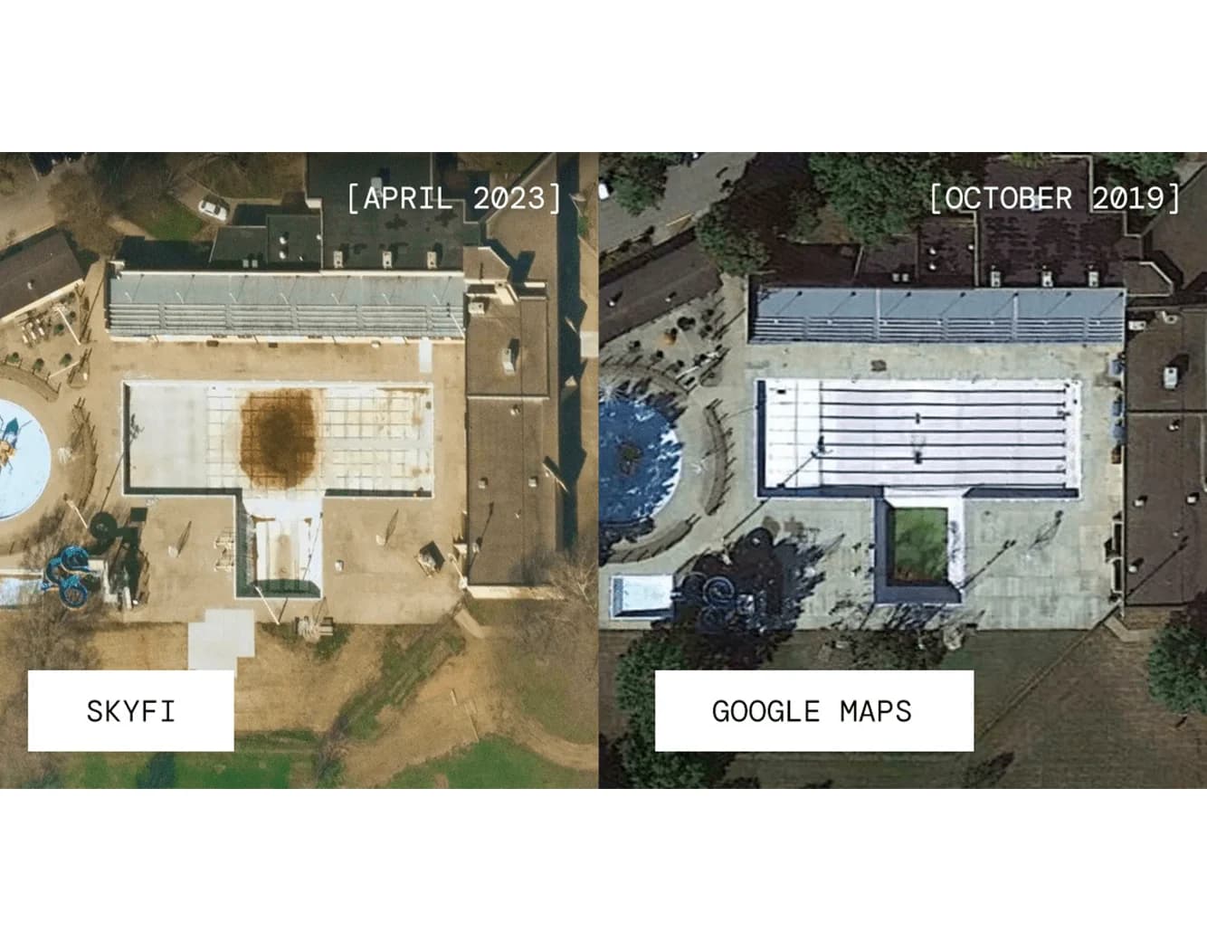
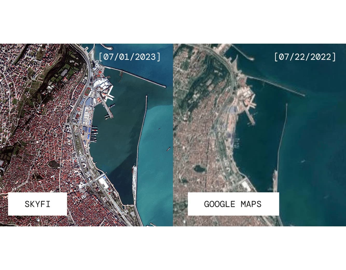
Data Freshness: SkyFi provides near real-time updates (delivered within 24 hours), significantly outperforming Google’s imagery, which can be 6 to 12 months old.
Resolution & Detail: SkyFi offers up to 30 cm resolution, allowing for precise tasks like counting vehicles, monitoring construction progress, or tracking urban development.
Professional Analytics: Unlike Google's consumer interface, SkyFi supports NDVI vegetation monitoring, GIS integration, and API automation for agriculture, environmental research, and disaster response.
Introduction to Satellite Maps
Satellite maps are an innovative way to view and understand our world. They provide a bird's eye view, offering unmatched perspective and insight. From everyday navigation to environmental research, these tools have become integral to our lives.
Brief Overview of Google Maps
When you think about satellite maps, the name Google Maps is likely the first that comes to mind. Google has indeed set a high standard with its robust mapping features and ease of use. But is it the best there is?
Before jumping in, did you know Google Maps’ imagery is primarily taken from a plane – not a satellite?
The Rise of SkyFi
What is SkyFi?
SkyFi is a revolutionary player in the satellite imagery space, using the latest technology to offer high-resolution imagery and near real-time updates. Near real-time means that after a satellite image is captured, the user usually receives it within 24 hours, as opposed to the 6-12 months it takes for Google to update their imaging. SkyFi's mission is to use this up-to-date satellite mapping to transform how we see and interact with our world.
What Makes SkyFi Unique?
SkyFi's High-Resolution Satellite Imagery
SkyFi's real strength lies in the incredible detail of its high-resolution satellite imagery which it sources from 50+ commercial satellite partners. By enabling users to easily select from a multitude of satellite imagery options, they can get the answers they need on demand. With the highest resolution of 30 cm per pixel, SkyFi images allow you to count cars in a parking lot or track activity on a construction site.
Near Real-Time Updates with SkyFi
Time stands still for no one, and SkyFi understands this. Hence, it provides near real-time updates to its users, ensuring the most accurate and up-to-date satellite maps of our ever-changing world.
Wide Coverage of SkyFi
From major cityscapes to remote landscapes, SkyFi's coverage is extensive. Its layered satellite images offer users the chance to explore places they've never been and to revisit familiar ones, and improves workflow across various industries in need of satellite imagery and analytics.
Comparing Google Maps and SkyFi
Coverage and Updates
While Google has impressive mapping capabilities, SkyFi offers a more viable alternative to Google Maps for satellite view, thanks to its timeless high-resolution imagery. Ever tried to zoom in on Google and realized the image is not up-to-date? That's where SkyFi shines with its updated library of existing imagery and ability to task a satellite for a new image, resulting in the production of more recent satellite images than Google.
Detailing and Resolution
When it comes to resolution, Google is no slouch. That’s because most of Google Maps highest resolution is taken from a plane, also known as aerial imagery. However, in remote locations, and outside of cities, where Google Maps does not frequently fly airplanes, SkyFi imagery is able to compete with Google Maps resolution, providing a clear satellite view of more rural areas.
Geometric Accuracy
SkyFi caters to a more professional audience, and prioritizes technical accuracy and precision over cosmetics as a result. While Google’s imagery may be more visually appealing, SkyFi’s updated library of existing imagery and ability to task a satellite for a specific, new image allows it to focus on more geometrically accurate images that reflect actual daily operations.
Data Integration
While Google Maps offers a basic web-based user interface with limited measuring options and export abilities, SkyFi provides a business-friendly alternative to satellite view. Through direct downloads of satellite data, Geographic Information System (GIS) software integration, and its very own Application Programming Interface (API) for workflow automation, SkyFi continues to prove itself as an industry leader in satellite imagery.
The Future of Satellite Mapping: SkyFi's Vision
SkyFi aims not just to compete with the existing satellite mapping services but to redefine the industry's standards. With its emphasis on high-resolution, near real-time updates, and wide coverage, SkyFi is shaping the future of satellite mapping.
So, is there a better satellite map than Google? Well, it seems SkyFi is making a compelling case! With its high-resolution imagery, near real-time updates, and extensive coverage, it's challenging the status quo and expanding our understanding of the world.
Google Maps vs. Competitors - FAQs
Is SkyFi's satellite imagery really high-resolution?
Yes, SkyFi offers high-resolution commercial satellite imagery, providing details that are often superior to other satellite mapping services.
What kind of coverage does SkyFi offer?
SkyFi offers wide coverage for their up-to-date satellite maps, ranging from urban cityscapes to remote landscapes.
How does SkyFi compare to Google in terms of updated and accurate images?
While both offer impressive services, SkyFi has an edge with its existing image library updated with images all over the world and its ability to task a satellite for a new image, proving it to be a better alternative for satellite view.
Is SkyFi the future of satellite mapping?
SkyFi's vision and unique features certainly position it as a potential leader in the future of satellite mapping.
Related Satellite News & Stories from SkyFi
Sources:


