Understanding the Resolution Spectrum for Satellite Imagery & Beyond
When it comes to satellite imagery, resolution is everything, but resolution is not a single measurement; it’s a spectrum. Spatial, temporal, and spectral resolution each shape what a satellite can see, how often it can see it, and how much information it can extract from what it captures.
Mastering this spectrum is what separates generic data from truly powerful Earth intelligence. Whether you are in agriculture, defense, environmental monitoring, or financial services, understanding the resolution spectrum is the key to unlocking the full potential of high-resolution, near real-time satellite imagery for your industry.
TL;DR (Too Long; Didn’t Read)
What is the resolution spectrum? The resolution spectrum is the combined range of spatial, temporal, and spectral resolutions that work together to determine the clarity, frequency, and depth of information captured in satellite imagery and other data. It is the foundational framework behind high-quality Earth observation.
What are the three types of resolution? Spatial resolution defines the level of physical detail in an image, with the finest commercial satellite imagery reaching as low as 25 cm per pixel. Temporal resolution determines how frequently a satellite revisits a location. Spectral resolution governs how many wavelength bands a sensor can detect, enabling identification of features invisible to the naked eye.
What is the resolution trade-off? No single satellite can maximize all three resolution types simultaneously. A system optimized for high spectral resolution typically sacrifices spatial detail, and vice versa, which is why access to a diverse network of satellite providers is strategically essential.
What factors affect the resolution spectrum? Key factors include sensor technology, data processing tools, environmental conditions such as cloud cover and atmospheric interference, hardware components, and emerging innovations in AI and machine learning.
What Is the Resolution Spectrum?
The resolution spectrum refers to the combined range of spatial, temporal, and spectral resolutions that enhance the clarity and precision of imagery, videos, and data. It integrates multiple resolution types to deliver a comprehensive view of the captured scene or dataset.
The resolution spectrum is a critical framework for capturing and interpreting data with precision. By leveraging it, industries can extract meaningful information from raw imagery and other datasets, ensuring high-quality outputs.
For example, spatial resolution determines the level of detail visible in an image, temporal resolution focuses on the frequency of data capture, and spectral resolution highlights the ability to distinguish different wavelengths of light. Together, these components form the resolution spectrum, which is essential for accurate analysis in various fields, including the geospatial technology and Earth observation that produces satellite imagery..
How Does the Resolution Spectrum Relate to Specific Resolution Types?
The resolution spectrum operates as a unifying framework that connects spatial, temporal, and spectral resolutions. Each type of resolution addresses a specific aspect of image or data quality, and their interplay enhances overall accuracy.
Spatial resolution focuses on detail, determining how clearly objects are represented in an image. Higher spatial resolution means smaller objects are distinguishable.
Temporal resolution measures how often data is captured over time. Frequent data capture allows for more detailed time-based analysis.
Spectral resolution relates to the ability to distinguish different wavelengths in the electromagnetic spectrum, enabling the identification of materials or substances based on their reflectance.
When these resolution types are combined, they create a comprehensive representation of the observed area or object. For instance, in remote sensing, spatial resolution identifies physical features, temporal resolution monitors changes over time, and spectral resolution distinguishes between vegetation and water. Together, they provide an integrated view, allowing for better analysis and decision-making.
Real-World Applications of the Resolution Spectrum
The resolution spectrum has a wide range of applications across various industries, where it is instrumental in enhancing efficiency, accuracy, and decision-making.
Photography: High-resolution cameras use the resolution spectrum to capture detailed images with vivid colors. Spatial resolution ensures clarity, while spectral resolution enhances color accuracy.
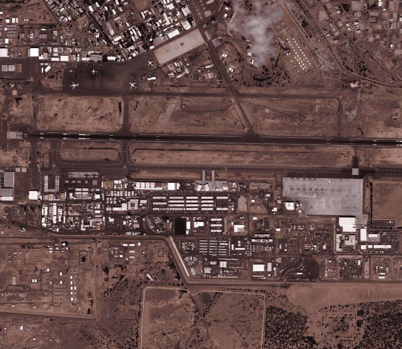
Satellite Imagery: Remote sensing technologies utilize the resolution spectrum to provide detailed maps and analyses for agriculture, disaster management, and urban planning.
Video Production: Temporal resolution ensures smooth transitions and motion in high-definition videos, enhancing the viewer experience.
Scientific Research: The resolution spectrum is critical in fields like astronomy and physics, where high spectral resolution helps identify substances and analyze light spectra.
Radiology: Medical imaging technologies like MRIs, CT scans, and ultrasounds rely on the resolution spectrum to deliver clear, detailed diagnostic images.
Geographic Information Systems (GIS): High-resolution satellite imagery providers such as SkyFi rely on the resolution spectrum to determine the level of detail, frequency, and range of wavelengths their imagery can capture, which directly dictates how useful that data is for different GIS applications.
These applications illustrate the versatility of the resolution spectrum in improving outcomes across diverse domains.
Why Is the Resolution Spectrum Critical for High-Resolution Outputs?
The resolution spectrum plays a vital role in achieving high-resolution outputs by enhancing the ability to distinguish fine details and interpret complex data.
One of its key strengths is the integration of multiple resolution types. By combining spatial, temporal, and spectral resolutions, the resolution spectrum allows for more nuanced analyses and accurate interpretations. For example, in environmental monitoring, this integration helps identify subtle changes in vegetation or water quality over time.
Additionally, the resolution spectrum improves decision-making by providing detailed insights. Industries such as agriculture, defense, and urban planning benefit from the precise information derived from high-resolution imagery and data.
Finally, advancements in technology have amplified the significance of the resolution spectrum, enabling industries to address complex challenges with innovative solutions.
How Does the Resolution Spectrum Help Produce High-Resolution Satellite Imagery?
The resolution spectrum in satellite imagery encompasses three key dimensions: spatial, spectral, and temporal, each determining a different aspect of image quality.
Spatial resolution defines the physical detail captured, with the finest commercial imagery reaching as low as 25 cm per pixel. Spectral resolution governs how many wavelength bands a sensor can detect, enabling identification of features invisible to the human eye. Temporal resolution dictates how frequently a satellite revisits a location.
Essential Trade-Offs
The fundamental challenge of the resolution spectrum is that no single satellite can maximize all three dimensions at once. A system optimized for high spectral resolution will typically sacrifice spatial detail, and vice versa.
Satellite imaging providers must make deliberate trade-offs depending on the application, which is why different satellites are engineered for different use cases, and why access to a diverse network of providers is so strategically valuable.
The Genius of SkyFi’s Near Real-Time Satellite Imagery
SkyFi directly addresses this challenge by aggregating the full resolution spectrum across a network of industry-leading satellite partners into one seamless platform. Users gain access to optical, Synthetic Aperture Radar (SAR), multispectral, and aerial data, covering ultra-high spatial resolution imagery, all-weather SAR imagery, and high-frequency temporal coverage with near real-time updates.
Rather than forcing users to choose one resolution priority over another, SkyFi gives businesses, agencies, and industries the flexibility to access the right type of imagery for any given mission, application, or industry need.
Factors That Affect the Resolution Spectrum
Several factors influence the effectiveness of the resolution spectrum. Understanding these factors is essential for optimizing its use in various applications:
Sensor Technology: Advanced sensors improve resolution capabilities, enabling more precise data capture.
Data Processing Tools: The software used to analyze and enhance resolution plays a critical role in producing high-quality outputs.
Environmental Conditions: Factors such as lighting, weather, and atmospheric interference can impact resolution quality.
Hardware Components: Features like slit width, diffraction grating, and pixel density in spectrometers directly affect spectral resolution.
Technological Innovations: Emerging technologies, including AI and machine learning, enhance the ability to process and optimize resolution spectrum data.
For instance, when collecting satellite imagery, cloud cover or poor lighting can reduce spatial resolution. Advanced processing techniques can mitigate these challenges, ensuring accurate results despite adverse conditions.
Measuring and Analyzing the Resolution Spectrum
Measuring the resolution spectrum involves a combination of theoretical calculations and practical testing. Spectrometers are commonly used to assess spectral resolution, while imaging tools measure spatial and temporal aspects.
One critical metric for spectral resolution is the Full Width at Half Maximum (FWHM), which measures the width of a spectral peak at half its maximum intensity. This metric provides a clear indicator of a spectrometer's ability to distinguish between closely spaced wavelengths.
Additionally, theoretical calculations, such as the resolution factor and wavelength range, provide benchmarks for device performance. However, real-world measurements are essential to account for variables like instrument sensitivity and environmental conditions.
Accurate measurement and analysis of the resolution spectrum are crucial for ensuring data reliability and usability.
Limitations of the Resolution Spectrum
Resolution-Sensitivity Trade-Off
While the resolution spectrum provides significant advantages, it is not without its challenges. One of the primary limitations is the trade-off between resolution and sensitivity. For example, enhancing spectral resolution often reduces the ability to detect faint signals, as narrower wavelength ranges require more light to produce accurate measurements.
Storage & Processing Demands
Another limitation is the storage and processing demands associated with high-resolution data. Large datasets, especially those generated from hyperspectral imaging or high-temporal-resolution video, require robust computational resources to store, analyze, and interpret effectively.
Spectral Line Difficulties
Additionally, overlapping spectral lines can present challenges in specific applications, such as hyperspectral imaging, where closely spaced wavelengths may be difficult to distinguish. This can complicate the interpretation of data and limit its practical utility in certain scenarios.
Cost of Resources
Cost is also a factor to consider. High-resolution sensors and imaging systems are often expensive, which can make their adoption prohibitive for smaller organizations or projects with limited budgets.
Despite these challenges, advancements in data processing and hardware design are addressing many of these limitations, making the resolution spectrum more accessible and efficient.
Optimizing and Enhancing the Resolution Spectrum
Optimizing the resolution spectrum requires careful planning and the use of appropriate tools and techniques. The first step is identifying the specific requirements of a project, such as whether spatial, temporal, or spectral resolution is most critical for achieving the desired outcomes.
Software Solutions
Software solutions are pivotal in enhancing resolution. For instance, image processing software can correct distortions, remove noise, and enhance clarity in satellite images. Similarly, machine learning algorithms can optimize temporal resolution by predicting data points between captured frames.
Various Hardware Options
Investing in versatile hardware is another effective strategy. Advanced spectrometers and imaging devices with adjustable settings allow for customization based on the needs of a particular application. This flexibility ensures that the resolution spectrum can be tailored to achieve optimal results.
Keeping Up With Advancements
Finally, staying informed about technological advancements is essential. Emerging innovations, such as compact high-resolution devices and AI-powered analytics, are making it easier to harness the full potential of the resolution spectrum.
Innovations in the Resolution Spectrum
Hyperspectral Imaging Systems
The resolution spectrum is poised for significant advancements as technology continues to evolve. One of the most promising trends is the development of hyperspectral imaging systems, which offer unparalleled detail by capturing hundreds of narrow spectral bands. These systems are transforming industries such as agriculture, where they enable precise monitoring of crop health, and environmental management, where they facilitate the detection of subtle changes in ecosystems.
AI Analysis
Artificial intelligence is also playing a critical role in enhancing the resolution spectrum. AI algorithms can analyze vast datasets quickly and efficiently, uncovering patterns and insights that would otherwise go unnoticed. For example, AI-driven systems are being used to improve temporal resolution in satellite imaging, ensuring more frequent updates without compromising image quality.
High-Res Sensor Reduction
The miniaturization of high-resolution sensors is another exciting development. Compact, affordable devices are expanding access to advanced imaging technologies, allowing smaller organizations to benefit from the resolution spectrum’s capabilities.
New Wavelength Exploration
Additionally, exploration beyond traditional wavelengths is opening up new possibilities. By extending the range of detectable wavelengths, scientists and engineers can uncover new applications for the resolution spectrum, from pollution detection to planetary exploration.
Which Industries Does the Resolution Spectrum Serve?
The resolution spectrum enhances day-to-day operations for many prominent industries served by SkyFi, including military & defense, financial services, environmental management, agriculture, insurance, energy, mining, construction & real estate, and government agencies.
Military & Defense
For military applications, all three resolution dimensions carry critical weight. High spatial resolution enables identification of vehicles, structures, and equipment on the ground, while high spectral resolution, particularly through multispectral and hyperspectral sensors, supports target discrimination and the detection of camouflaged assets.
Rapid revisit, rapid data delivery, and day/night, all-weather capabilities may do more to boost the military utility of satellite imagery than improved resolution alone.
The resolution spectrum also benefits the military in the form of SAR. Unlike optical imaging systems, SAR provides all-weather, day-and-night surveillance capabilities, making it indispensable for reconnaissance, target acquisition, and battlefield monitoring. SAR's ability to generate high-resolution images regardless of lighting or weather conditions gives defense forces a significant tactical advantage.
SkyFi directly utilizes the resolution spectrum for military operations by providing defense and security teams with access to 150+ satellite sources, AI-enabled analytics, and high-resolution imagery deliverable directly into Common Operational Picture (COP) systems and ATAK for faster, mission-ready decision-making.
Financial Services
Hedge funds and quantitative investors pioneered the use of satellite imagery for financial advantage, with the most famous example being counting cars in Walmart parking lots to predict quarterly revenue before official earnings announcements.
Today, applications have expanded to monitoring oil storage tank levels, tracking construction activity at new retail locations, and assessing real estate development progress across entire metropolitan areas.
High spatial and temporal resolution are the dominant priorities here, as financial analysts require sharp, frequently updated imagery to detect subtle changes in economic activity before they are reflected in traditional market data. SkyFi's platform gives financial institutions access to verified, high-frequency Earth intelligence that reveals real economic activity in near real time.
Environment
Environmental monitoring relies heavily on spectral resolution, as identifying pollution, deforestation, ecosystem changes, and climate shifts requires the ability to detect wavelengths of light far beyond the visible spectrum.
NASA's Earth satellites collect NDVI data to measure the greenness of vegetation for studies of climate change, agriculture, and natural disasters, using the difference between near-infrared and red reflectance to quickly assess the condition of plants and detect stress before it becomes visually apparent.
High temporal resolution is equally important, enabling consistent monitoring of environmental changes over time. SkyFi supports environmental applications through NDVI color maps, multispectral imagery, and open satellite data that provide actionable insights for conservation, climate research, and environmental compliance.
Agriculture
The accuracy of crop type identification improves as imagery moves from medium spatiotemporal resolution to high spatiotemporal resolution, with satellites like PlanetScope from Planet Labs, an industry leader and proud SkyFi partner, offering a high spatial resolution of 3 meters with daily revisits, enabling more granular and frequent field-level monitoring.
Spectral resolution is equally vital, as multispectral and near-infrared bands allow farmers to detect crop stress, soil moisture levels, and yield variation invisible to the naked eye. SkyFi's NDVI color maps and multispectral imagery give agricultural users the field-level precision needed to make smarter, faster decisions about irrigation, fertilization, and harvest planning.
Insurance
Insurers use satellite imagery to assess properties at scale without sending adjusters into the field. High-resolution imagery reveals roof conditions, proximity to flood zones, vegetation encroachment, and other risk factors.
After disasters, satellite damage assessment enables rapid claims processing. ICEYE's flood data, for example, can determine which specific properties were inundated before a homeowner even files a claim.
High spatial resolution drives accurate property-level assessment, while high temporal resolution enables before-and-after comparisons critical for claims validation. SkyFi's near real-time imagery and change detection capabilities allow insurers to process claims faster and with greater accuracy than traditional ground-based methods.
Energy
Energy, oil, and gas sectors rely on satellite data for infrastructure monitoring, exploration, and environmental compliance, detecting pipeline routes, assessing land use, and monitoring remote sites without requiring physical presence.
High spatial resolution supports the detection of infrastructure changes, leaks, and encroachments across pipeline corridors and remote facilities, while SAR imagery enables consistent monitoring in all weather conditions.
SkyFi's all-weather SAR capabilities and high-resolution optical imagery give energy companies persistent visibility over critical infrastructure, supporting both operational efficiency and regulatory reporting.
Mining
During exploration, specialized sensors detect mineral alteration signatures and structural features. For operational mines, regular satellite monitoring enables accurate measurement of disturbed areas for regulatory reporting.
During rehabilitation, multispectral capabilities help quantify vegetation cover and assess plant health. Spectral resolution is the defining priority for mining, as short-wave infrared bands enable detection of specific minerals and alteration zones that are invisible at standard wavelengths.
SkyFi's access to high-resolution multispectral and hyperspectral imagery supports mining operations across the entire lifecycle, from early-stage exploration to environmental rehabilitation and compliance.
Construction & Real Estate
High spatial and temporal resolution are the primary drivers in construction and real estate, where detailed site-level imagery and frequent updates are needed to track development progress, identify delays, and monitor land use changes.
Planet's SkySat constellation reaches 50 cm resolution with daily updates, making it ideal for tracking construction progress or agricultural changes, while Vantor operates high-resolution satellites capturing 30 cm to 50 cm imagery, serving government and commercial clients.
SkyFi provides construction teams and real estate developers with on-demand access to both archive and tasked imagery, enabling change detection, site monitoring, and progress documentation across multiple locations simultaneously.
Government
Government agencies operate across the broadest range of applications of any sector: urban planning, border security, land management, disaster response, resource allocation, and public infrastructure. Therefore, all three resolution dimensions are simultaneously relevant and mission-critical.
A wide international expansion of satellite imagery systems is taking place, with these systems becoming increasingly capable in the areas of resolution, spectral coverage, revisit time, and data delivery time. This provides significant utility for current intelligence, change detection, targeting, and surveillance.
High spatial resolution supports detailed mapping and infrastructure assessment, high spectral resolution enables land classification and environmental monitoring, and high temporal resolution provides the frequency of coverage needed for ongoing situational awareness.
SkyFi gives government agencies access to verified, high-frequency Earth intelligence that reveals real economic activity in near real time, enabling tracking of commodities, monitoring of supply chains, assessment of infrastructure, and quantification of on-the-ground signals.
Combined with ATAK plugin integration, SAR all-weather capabilities, and a self-service platform that removes traditional contracting barriers, SkyFi positions itself as a comprehensive geospatial intelligence and high-resolution satellite imagery resource for government agencies at every level.
The Future of the Resolution Spectrum
The resolution spectrum is a powerful framework that enhances the quality and precision of images, videos, and data across a wide range of applications. By integrating spatial, temporal, and spectral resolutions, it provides a comprehensive view of the observed scene, enabling industries to make more informed decisions and achieve better outcomes.
Whether in satellite imagery, photography, video production, or scientific research, the resolution spectrum plays a vital role in driving innovation and improving efficiency. Despite its limitations, advancements in technology are continually pushing the boundaries of what is possible, making the resolution spectrum more accessible and effective than ever before.
As the resolution spectrum evolves, it will undoubtedly unlock new opportunities for exploration and discovery. From enabling detailed environmental monitoring to advancing medical imaging technologies, its potential is vast and transformative. Understanding and leveraging the resolution spectrum is key to staying at the forefront of innovation in a rapidly changing world.
For those interested in learning more about the resolution spectrum and its applications, resources and tools are available to help unlock its full potential, including SkyFi’s high-resolution satellite imagery This comprehensive guide serves as a starting point for exploring the possibilities offered by this remarkable framework.
Resolution Spectrum & Satellite Imagery FAQs
What is the resolution spectrum?
The resolution spectrum is the combined range of spatial, temporal, and spectral resolutions that work together to enhance the clarity, frequency, and depth of information captured in satellite imagery and other data.
What are the three types of resolution in satellite imagery?
The three types are spatial resolution (the level of physical detail in an image), temporal resolution (how frequently a satellite revisits a location), and spectral resolution (the ability to detect different wavelengths of light beyond what the human eye can see).
What is the difference between spatial and spectral resolution?
Spatial resolution refers to how much physical detail is visible in an image. The smaller the pixel, the sharper the image. Spectral resolution refers to how many wavelength bands a sensor can distinguish, enabling identification of materials and features that are invisible at standard wavelengths.
Why can't a satellite maximize all three resolution types at once?
There is an inherent trade-off within the resolution spectrum, as a system optimized for high spectral resolution typically sacrifices spatial detail, and vice versa. This is why different satellites are engineered for different use cases.
What factors affect the resolution spectrum?
Key factors include sensor technology, data processing software, environmental conditions such as cloud cover and lighting, hardware components like pixel density and diffraction grating, and emerging innovations in AI and machine learning.
What are the main limitations of the resolution spectrum?
The primary limitations include the trade-off between resolution and sensitivity, the significant storage and processing demands of high-resolution data, difficulties distinguishing overlapping spectral lines in hyperspectral imaging, and the high cost of advanced sensors and imaging systems.
Related Satellite News & Stories from SkyFi
Sources:
Mikkel Rasmussen is a Senior Remote Sensing Specialist at SkyFi, where he develops image processing methods, derived-data prototypes, and geospatial workflows that support scalable Earth observation products. With more than a decade of experience working across commercial and open-source satellite imagery, he collaborates closely with engineering, product, and UX teams to ensure efficient, operationally sound geospatial platforms.


