Satellite Imagery for Flood Management: Everything to Know (Updated 2026)
Flooding impacts more people than any other form of natural disaster and substantially impedes sustainable land development. Satellite imaging has revealed that the total population of individuals exposed to floods has drastically increased from 58 to 86 million from 2000 to 2015, and studies indicate that this number has and will continue to increase.
Because of this, SkyFi sees the immense potential of Geographic Information System (GIS) and satellite imagery in improving flood detection, damage assessment, property risk evaluation, and urban flood monitoring.
Key Takeaways (TLDR):
Rapid Disaster Response: Satellite imagery provides high-resolution data that allows decision-makers to bypass ground surveys and map flood damages in near real-time.
Precision Damage Assessment: By utilizing change detection algorithms to compare pre- and post-flood imagery, organizations can instantly identify impacted infrastructure and prioritize relief efforts.
All-Weather Monitoring with SAR: Synthetic Aperture Radar (SAR) technology is a critical tool for flood management because it can penetrate cloud cover and capture data at night, ensuring constant monitoring regardless of weather conditions.
Predictive Terrain Modeling: Integrating Digital Terrain Models (DTM) with satellite data allows urban planners to simulate water movement and identify high-risk elevation zones before a flood occurs.
Scalable GIS Accessibility: SkyFi is actively democratizing access to Earth observation data, making enterprise-grade geospatial intelligence available to local agencies and first responders for more effective mitigation.
How Does Satellite and GIS Imagery Help Manage Floods?
How is satellite imagery used in disaster management?
Satellite view of flooding measures rapid and accurate information about disaster locations, allowing decision-makers to quickly assess situations and plan effective responses.
How do satellites assist in flood mitigation?
Satellites maintain communication during crises, ensuring that critical operations like airports, shelters, healthcare facilities, and utilities continue functioning, thus supporting first responders.
How does SkyFi enhance satellite imagery accessibility for flood management?
SkyFi simplifies access to high-resolution satellite imagery and data analytics, providing a user-friendly platform for effective flood management. SkyFi’s mission is to make this technology accessible to all, enabling timely and informed decision-making during flood events.
What future flood management advancements can be expected from SkyFi?
SkyFi will continue to improve its offerings, enhancing the spatial and temporal resolution of commercial satellite imagery and integrating AI for more precise and automated flood damage assessments. We are dedicated to providing innovative solutions for a safer and more prepared world.
High-Resolution Satellite Flood Damage Assessment
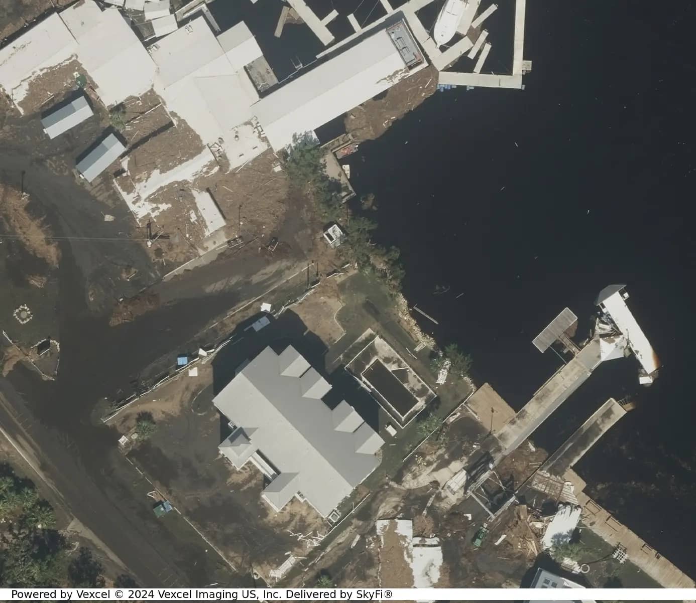
Traditional flood damage assessments rely heavily on ground surveys, which are time-consuming, costly, and often dangerous. Satellite imagery offers a more efficient alternative, providing accurate damage assessments quickly and safely.
By capturing high-resolution satellite images of flood-prone areas before and after a flood, satellites enable a clear comparison to identify changes and damage.
Pre and Post-Flood Satellite Imagery
Satellites capture detailed images of areas before a flood occurs, creating a baseline for comparison. After the flood, new images are taken to assess the extent of inundation and damage. This approach helps in identifying affected areas promptly, aiding in the prioritization of response efforts.
Change Detection for Flood Analysis
SkyFi’s advanced change detection software and algorithms analyze the differences between pre- and post-flood images, providing a visual representation of the flood's impact. This method allows for rapid identification of damaged areas, facilitating a more effective response.
SkyFi helps flood mitigation through its detailed reports and analysis for urban development, environment impacts, and disaster response, to name just a few.
How Do Digital Terrain Models (DTM) and Flood Maps Help Flood Management?
SkyFi integrates high-resolution satellite-imagery with DTMs to assess flood risk. The combination of these technologies provides crucial geospatial data for hazard analysis and climate change monitoring.
DTMs provide precise and essential elevation data for flood-mapping in areas that easily attract floods. DTMs can help identify these areas that are more prone to flooding by monitoring water movement across a terrain, allowing for emergency response teams to plan early.
The integration of DTMs with current satellite images with near real-time updates allows for the generation of elaborate flood maps. These maps pinpoint vulnerable infrastructure, residential zones, and ecosystems, allowing for early risk assessment from urban planners.
Quantifying Flood Impact with Satellite Imagery and SAR
Visual assessments are valuable, but quantifying the flood's impact is essential for informed decision-making. Remote sensing technologies, such as Synthetic Aperture Radar (SAR) and multispectral imaging, provide crucial data for this purpose.
Water Extent Mapping: SAR data can map the extent of flooding accurately, even through cloud cover or at night. This helps estimate the affected population and infrastructure.
Damage Assessment: Multispectral imagery identifies changes in land cover, estimating damage to vegetation, buildings, roads, and other assets.
Elevation Data: LiDAR and other elevation data products provide precise terrain information, aiding in flood modeling and understanding how the landscape influences flood dynamics.
Water Quality Monitoring: Remote sensing can also monitor changes in water quality, detecting contamination and pollution caused by floodwaters.
These data points assist authorities and flood relief organizations in allocating resources effectively, ensuring targeted and efficient recovery efforts.
Supporting Flood Relief Efforts
In the aftermath of a flood, rapid and targeted assistance is crucial. SkyFi’s open source satellite data plays a key role in identifying critical areas that need immediate help, such as stranded populations and damaged infrastructure. This information is vital for planning efficient routes for aid delivery and ensuring access to affected regions.
Ongoing satellite monitoring allows for real-time tracking of flood conditions, enabling dynamic adjustments in relief operations. This flexibility ensures timely and responsive assistance as floodwaters recede or spread.
Flood Detection Challenges and Future Directions for Satellite Imagery
Despite significant advancements, challenges remain in using satellite technology for flood damage assessment. Enhancing the spatial and temporal resolution of satellite imagery is essential for more detailed and timely information. Ensuring data accessibility, particularly in remote or underserved regions, is another critical issue.
Integrating satellite data with other sources, such as social media and ground reports, can improve the accuracy of damage assessments. Artificial intelligence (AI) and machine learning algorithms offer promising prospects for automating damage assessment and change detection within satellite imagery.
International collaboration is also crucial to addressing these challenges. Sharing data, expertise, and resources globally can enhance flood monitoring and response capabilities, building resilience against flood disasters.
Looking Ahead: Enhancing Flood Management with Satellite Technology
Satellite imagery in flood damage assessment represents a significant advancement in disaster response. By combining remote sensing technology with data analytics, SkyFi is better equipped to mitigate the immediate impacts of floods and build a more resilient future.
SkyFi’s Vision for Flood Management
SkyFi is committed to utilizing the power of Earth observation technology to aid in disaster management and recovery, ensuring the protection of lives and property in the face of these natural disasters.
SkyFi operates across multiple industries, including military and defense, environmental management, and financial services, allowing for quick and effective disaster mitigation and response. As technology continues to advance, the capacity to respond effectively to floods will improve, providing a safer and more prepared world for all.
Related Satellite News & Stories from SkyFi
Sources:
Evan Achiron is the Head of Marketing and Communications at SkyFi where he is responsible for growing the company’s brand positioning and thought leadership. He is an experienced brand builder and B2B marketer with particular experience in GovTech SaaS, Climate Tech AI, public policy, and government advisory industries.


