Types of Resolution: A Comprehensive Guide to Understanding Their Impact and Applications
TL;DR
Explore the types of resolution and their importance in geospatial technology.
Learn about spatial, temporal, spectral, radiometric, and display resolutions.
Understand how different resolutions impact industries like agriculture, urban planning, and disaster response.
Discover practical applications and tools to evaluate resolution effectively.
Gain insights from over 4 years of experience in Earth observation and geospatial technology.
Understanding "Types of Resolution"
The "types of resolution" refer to critical factors that determine the level of detail and clarity in images and datasets. These resolutions play a pivotal role in a wide range of applications, from satellite imaging and environmental monitoring to everyday technologies like display screens. Understanding these resolutions is essential for effective data analysis and decision-making across industries.
Over years of advancements in geospatial technology, experts have developed methods to harness high-resolution data, enabling industries to gain actionable insights. This comprehensive guide explores these resolutions and their applications.
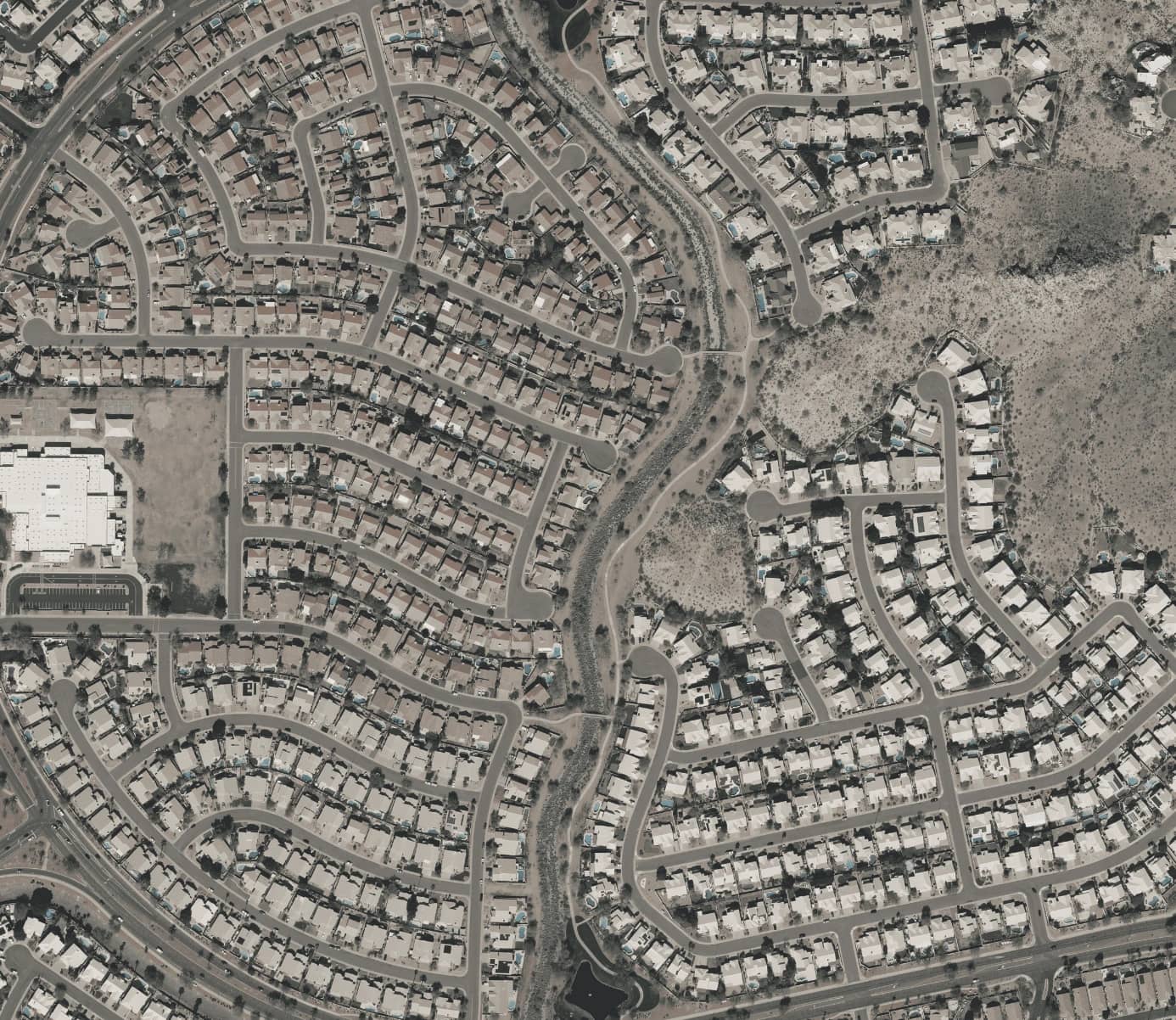
Spatial Resolution: The Foundation of Detail
Spatial resolution describes the smallest object that can be distinguished in an image. For example, a spatial resolution of 30 cm indicates the ability to differentiate objects as small as 30 cm apart. This measure is crucial for applications requiring high levels of detail, such as urban planning and infrastructure mapping.
One prominent use of spatial resolution is in environmental conservation, such as detecting deforestation in remote areas. High-resolution images make it possible to monitor small-scale changes, such as illegal logging or canopy degradation. Similarly, in agriculture, spatial resolution supports precise analysis of crop health and field variability, enabling more efficient resource allocation.
Satellites like Pléiades Neo exemplify the potential of high spatial resolution, offering unparalleled clarity that enhances environmental, industrial, and disaster management efforts.
Temporal Resolution: Capturing Change Over Time
Temporal resolution refers to how frequently a specific location is imaged by a satellite, commonly known as revisit time. This measure is vital for time-sensitive applications, including disaster response and agricultural monitoring.
During events like floods or wildfires, high temporal resolution enables rapid updates, helping emergency teams respond effectively. Conversely, lower temporal resolution may leave critical gaps in data, delaying action. Advances in satellite constellations and directional pointing have significantly reduced revisit times, making high-frequency imaging more accessible.
High temporal resolution is instrumental in tracking seasonal changes in agriculture or urban expansion, ensuring timely decision-making for industries and governments alike.
Spectral Resolution: Beyond What Meets the Eye
Spectral resolution defines a sensor’s ability to capture data across different wavelengths of light, extending beyond the visible spectrum. This resolution is indispensable for specialized applications, such as analyzing vegetation health or detecting pollutants in water.
By capturing data in panchromatic, multispectral, or hyperspectral formats, spectral resolution enables detailed differentiation between materials or conditions. For example, monitoring coastal water quality relies on spectral resolution to identify algae blooms and pollutant levels. These insights are crucial for maintaining ecological balance and resource management.
The integration of spectral data with other resolutions enhances its effectiveness, providing a comprehensive understanding of the observed area.
Radiometric Resolution: Capturing Subtle Differences
Radiometric resolution measures a sensor’s ability to detect slight variations in energy or brightness levels. Higher radiometric resolution allows for more precise analysis, making it a key factor in applications such as detecting temperature changes or monitoring soil moisture levels.
In agriculture, radiometric resolution can identify stress in crops caused by pests or water shortages, enabling proactive measures. Similarly, subtle changes in land or vegetation features can be observed and analyzed for environmental conservation.
Combining radiometric data with spatial and spectral resolutions enhances analytical accuracy, highlighting the interdependence of resolution types.
Display Resolution: Everyday Applications
Display resolution refers to the number of pixels on a screen, affecting image clarity and detail. While commonly associated with entertainment and gaming, display resolution has significant implications in professional fields such as medical imaging and graphic design.
For instance, a radiologist analyzing diagnostic images relies on high-resolution screens to identify minute abnormalities. Similarly, professionals in design and video production require precise pixel detail to achieve their objectives.
Understanding display resolution highlights its interconnectedness with other resolution types and underscores its importance in both professional and personal contexts.
Integrating Resolutions for Maximum Impact
Each type of resolution—spatial, temporal, spectral, radiometric, and display—offers unique insights, but their integration provides a fuller understanding of complex phenomena. For example, combining high spatial resolution with frequent temporal updates enables real-time monitoring of urban growth or environmental changes.
Advances in technology, such as AI-driven super-resolution and multi-satellite constellations, have made it possible to overcome trade-offs between resolution types. These innovations allow for more detailed and frequent data collection, empowering industries to make informed decisions with greater confidence.
The interrelationship between resolutions is crucial for comprehensive geospatial analysis, highlighting the need for tailored approaches based on specific project requirements.
Evaluating and Optimizing Resolutions
Selecting the appropriate resolution for a project requires careful consideration of several factors, including cost, application needs, and technological constraints. Techniques like pansharpening and machine learning-based super-resolution enhance image clarity, optimizing data for analysis.
Advances in software and hardware have made it easier to evaluate and combine resolutions for various applications. For example, tools that integrate spatial and spectral data provide actionable insights for urban planning and agricultural monitoring.
While high-resolution imagery often involves higher costs and processing requirements, the value it adds to decision-making processes often outweighs these challenges.
Case Studies and Real-World Applications
High-resolution data has transformed industries in numerous ways. In urban planning, combining spatial and temporal resolutions has enabled cities to monitor expansion and infrastructure needs effectively. Agricultural projects have leveraged spectral and radiometric resolutions to improve crop health monitoring and optimize resource usage.
During natural disasters, real-time data from high-temporal-resolution satellites has proven critical for emergency response teams. These case studies underscore the practical value of understanding and applying different types of resolution to solve real-world problems.
The concept of "types of resolution" encompasses a range of measurements that collectively define the level of detail and accuracy in data analysis. From spatial and temporal to spectral and radiometric resolutions, each type serves a distinct purpose while complementing others to provide comprehensive insights. With advancements in geospatial technology, the ability to harness these resolutions continues to expand, offering solutions to challenges across various industries.
This guide highlights the transformative potential of resolutions in applications ranging from environmental monitoring to infrastructure development. By understanding and optimizing these measurements, organizations can unlock the full potential of their data, paving the way for innovation and informed decision-making.