Understanding Spatial Resolution for High-Resolution Satellite Imagery
Spatial resolution plays a vital role in satellite imagery, as it measures the level of detail in an image, defined by the size of each pixel. High spatial resolution provides clearer, more detailed imagery but requires more storage and processing power. It enhances operations in industries such as urban planning, disaster response, and environmental monitoring.
SkyFi, with four years of expertise in high-resolution, near real-time satellite imagery and geospatial technology, offers tailored solutions for various applications that utilize spatial resolution. This comprehensive guide explains spatial resolution and how it impacts decision-making in different sectors.
TL;DR (Too Long; Didn’t Read)
What is spatial resolution? Spatial resolution refers to the level of detail captured in a satellite image, defined by the physical size each pixel represents on the ground. A 30 cm spatial resolution, for example, means each pixel covers a 30 cm by 30 cm area, revealing features like individual rooftops, vehicles, and natural elements with precision.
Why does spatial resolution matter for satellite imagery? Spatial resolution determines how much actionable detail can be extracted from an image. High spatial resolution enables identification of specific structures, infrastructure damage, individual crops, and potential threats, while lower resolution only provides a broad overview unsuitable for detailed analysis.
How does spatial resolution differ from other resolution types? Spatial resolution defines the size of features visible in an image, while temporal resolution measures how often images are captured and spectral resolution describes the range of wavelengths recorded. All three work together to provide a comprehensive view for accurate analysis and decision-making.
Which industries rely on spatial resolution? Military and defense, government agencies, financial services, mining, environmental management, agriculture, insurance, energy, and construction and real estate all depend on high spatial resolution imagery to power operations, improve decision-making, and drive efficiency.
What is Spatial Resolution?
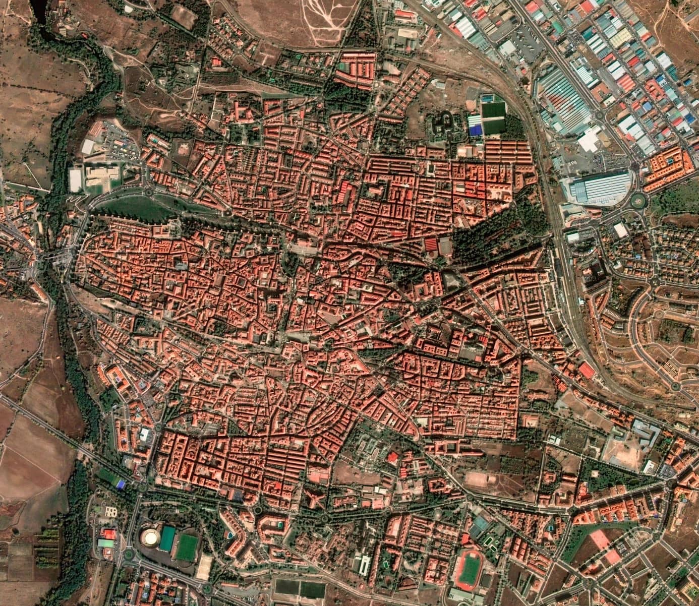
Spatial resolution refers to the amount of detail that can be observed in an image. Technically, it represents the physical size that each pixel in an image corresponds to in the real world. For instance, a satellite image with 30 cm spatial resolution means each pixel covers a 30 cm by 30 cm area on the ground.
Higher spatial resolution results in finer details, revealing features like individual rooftops, vehicles, or natural elements, while lower resolutions provide a broader overview of the landscape.
Understanding spatial resolution is essential for many industries. Whether it is used for urban planning, environmental monitoring, or disaster response, the clarity provided by higher spatial resolution allows for more informed decision-making. This critical aspect of geospatial imaging underpins many of the solutions offered by SkyFi.
Why is Spatial Resolution Important for Satellite Imagery?
Spatial resolution is critical for high-resolution satellite imagery because it determines the level of detail visible in an image. For example, in assessing flood damage to a bridge, low-resolution images might show a blurry outline, while high-resolution images can reveal cracks or blockages.
Similarly, in urban planning, detailed imagery identifies individual elements like bike lanes or sidewalks that would be indistinguishable at lower resolutions.
In fields such as disaster response, spatial resolution plays a vital role. High-resolution imagery enables teams to quickly identify blocked roads or damaged structures, helping to prioritize relief efforts.
Environmental studies often require varying levels of resolution, with higher detail needed for specific site analysis and lower resolution suitable for broader regional studies. The importance of spatial resolution lies in its ability to tailor data to the task at hand.
How Does Spatial Resolution Differ From Other Resolutions?
While spatial resolution focuses on the size of features in an image, other types of resolution address different aspects of data capture.
Temporal resolution measures how often images are captured, which is crucial for monitoring changes over time. Spectral resolution refers to the range of wavelengths recorded, such as infrared or visible light, and is often used in applications like agricultural monitoring or heat detection.
For example, in wildfire management, temporal resolution reveals how quickly a fire spreads, spectral resolution identifies areas of intense heat, and spatial resolution pinpoints the exact locations of structures or natural features at risk. Each resolution type complements the others, creating a comprehensive view that supports more effective analysis and decision-making.
Applications of Spatial Resolution Across Industries
Spatial resolution is applicable to many industries that SkyFi provides high-resolution imagery for, including military & defense, financial services, environmental management, agriculture, insurance, energy, mining, construction & real estate, and government agencies.
Military & Defense
For military and defense applications, such as the Android Team Awareness Kit (ATAK), spatial resolution can be the difference between identifying a threat and missing it entirely. National security applications use high-resolution imagery to distinguish between military and civilian equipment, providing essential data for informed decisions.
These applications highlight the versatility and value of spatial resolution in solving complex challenges. The finer the spatial resolution, the greater the tactical advantage in reconnaissance, target acquisition, and battlefield monitoring.
Government Agencies
Government agencies rely on high spatial resolution imagery for urban planning, land use mapping, infrastructure assessment, and disaster preparedness. In urban planning, high-resolution imagery is used to map traffic lanes, crosswalks, and parking areas with precision, enabling smarter infrastructure development.
Disaster response teams rely on spatial resolution to assess damage and identify accessible routes following natural disasters, such as hurricanes or earthquakes.
Financial Services
Spatial resolution is the engine behind satellite-driven financial intelligence. High-resolution imagery allows analysts to count cars in retail parking lots, measure oil storage tank levels, track shipping container activity, and monitor construction progress, all before this information appears in public financial reports.
The finer the spatial resolution, the more precise and actionable the economic intelligence that hedge funds and investment firms can extract ahead of the market.
Mining
In mining, spatial resolution determines how precisely exploration teams can identify mineral alteration signatures, fault lines, and structural features from orbit, narrowing down vast regions to the most promising targets before deploying costly ground teams.
High-resolution imagery also supports operational monitoring of specific minerals, accurate measurement of disturbed areas, and visual documentation of rehabilitation progress for regulatory compliance throughout the entire mining lifecycle.
Environmental Management
High spatial resolution is essential for environmental monitoring because it enables detection of changes at a level of detail that lower-resolution imagery simply cannot capture.
This high resolution enables everything from identifying illegal deforestation at the parcel level to mapping pollution sources, monitoring coastal erosion, and detecting habitat boundary changes. The finer the resolution, the earlier environmental degradation can be identified and the more targeted the response can be.
Agriculture
Spatial resolution allows satellite imagery to detect conditions at the individual field or plant level, making it foundational for precision farming. High-resolution imagery enables farmers to identify crop diseases, monitor soil moisture, assess canopy health, and detect anomalies as they emerge.
Insurance
Damage assessment for insurance claims is only truly reliable when it runs on high-resolution data that clearly shows damaged features at scale. In low or medium resolution imagery, you can see building outlines and shapes, but if you need to know exactly what is there, you need higher resolution satellite data.
High spatial resolution allows insurers to assess structural damage and flood inundation at the individual property level, enabling faster and more accurate claims processing without sending adjusters into hazardous areas.
Energy
High spatial resolution gives energy companies persistent, detailed visibility over pipelines, storage facilities, well pads, and remote infrastructure. This enables detection of leaks, encroachments, and operational changes across vast geographic areas without the cost or risk of physical inspections.
The ability to identify specific assets and measure changes at the site level makes spatial resolution a critical factor in both operational efficiency and environmental compliance.
Construction & Real Estate
In construction and real estate, high spatial resolution enables site-level tracking of excavation progress, material stockpiles, structural development, and surrounding land use changes. The level of detail provided by fine spatial resolution supports smarter project management, more accurate site selection, and better-informed investment decisions throughout the development lifecycle.
Determining the Right Spatial Resolution
The appropriate level of spatial resolution depends on the project’s objectives and requirements. For tasks requiring detailed analysis, such as infrastructure mapping, high-resolution commercial imagery (30 cm or better) is necessary.
Broader studies, such as regional environmental assessments, can use resolutions of 2 to 5 meters, which offer a balance between detail and cost. Factors such as data storage, processing capabilities, and budget also influence the choice of resolution.
High-resolution images require more storage and computational power, which can drive up costs. By analyzing project requirements, SkyFi provides tailored solutions that meet clients’ needs while managing resources efficiently.
Challenges and Innovations in Spatial Resolution
While spatial resolution offers significant advantages, it comes with challenges. High-resolution imagery can be expensive to acquire and store, and processing it requires advanced computing resources. Limitations in camera sensors and sampling intervals may also restrict the achievable resolution in some cases.
Innovations in technology are addressing these challenges. Advances in machine learning and artificial intelligence enable more efficient data processing and extraction of actionable insights.
These developments allow analysts to identify features such as damaged infrastructure or crop health with greater accuracy, maximizing the potential of spatial resolution for various applications.
Practical Examples of Spatial Resolution in Action
Spatial resolution plays a critical role in real-world scenarios. For example, after a natural disaster, it helps emergency teams identify navigable roads and assess building damage, ensuring timely and effective relief efforts.
In urban planning, high-resolution imagery supports the design of efficient traffic systems and pedestrian-friendly spaces. Environmental studies benefit from spatial resolution by enabling precise monitoring of changes in ecosystems, such as deforestation or wetland shrinkage.
National security applications rely on detailed imagery to monitor borders and identify potential threats.
Spatial Resolution in Radiology
Spatial resolution is also essential for radiology, as it is the foundation of accurate diagnosis. Spatial resolution helps determine how clearly and precisely a medical imaging system can distinguish small structures, abnormalities, and tissue boundaries within the body.
Spatial resolution in medical imaging refers to the ability to distinguish small details and discern two separate structures in an image. Higher spatial resolution provides more detailed images, improving diagnostic sensitivity.
Different imaging modalities offer different resolution capabilities depending on the clinical need. Current CT scanners have a spatial resolution of approximately 0.5 mm in all axes, while MRI typically achieves 1–2 mm for most sequences.
In clinical practice, higher spatial resolution facilitates the accurate identification of small pulmonary nodules or vascular boundaries, improving the diagnostic rate of early lesions.
The Impact of Spatial Resolution
Spatial resolution is a cornerstone of modern imaging and analysis, offering unparalleled clarity and precision for various applications. From urban planning and disaster response to environmental monitoring and national security, the ability to capture and interpret high-resolution imagery drives better decision-making.
By staying at the forefront of geospatial technology, SkyFi ensures that its clients receive the best solutions tailored to their unique challenges.
As technological advancements continue, the potential of spatial resolution grows, unlocking new possibilities for data analysis and visualization. Whether assessing environmental changes or planning infrastructure, leveraging the power of spatial resolution is essential for achieving accurate and impactful results.
Spatial Resolution & Satellite Imagery FAQs
What is spatial resolution in satellite imagery?
Spatial resolution refers to the level of detail captured in a satellite image, defined by the physical size each pixel represents on the ground. For example, a 30 cm spatial resolution means each pixel covers a 30 cm by 30 cm area, revealing fine details like individual rooftops or vehicles.
What is the difference between high and low spatial resolution?
High spatial resolution produces finer, more detailed imagery that can identify specific features like cracks in a bridge or individual crop rows. Low spatial resolution provides a broader overview of a landscape but lacks the detail needed for precise analysis or decision-making.
How does spatial resolution differ from temporal and spectral resolution?
Spatial resolution defines the size of features visible in an image, temporal resolution measures how frequently images are captured, and spectral resolution describes the range of wavelengths recorded. Each type complements the others to provide a more complete picture for analysis.
Why is spatial resolution important for disaster response?
High spatial resolution allows emergency teams to quickly identify blocked roads, damaged structures, and accessible routes following natural disasters. This enables faster, more targeted relief efforts that lower-resolution imagery simply cannot support.
What are the main challenges of using high spatial resolution imagery?
High-resolution imagery can be expensive to acquire and store, and processing it requires significant computing resources. Limitations in camera sensors and sampling intervals can also restrict achievable resolution in some cases.
Related Satellite News & Stories from SkyFi
Sources: