Using Satellite Imagery for Continuous Mine Monitoring
At SkyFi, we are committed to bringing advanced Earth observation capabilities to a broad range of applications. Satellite imagery has become a critical tool for industries such as traffic management, mineral exploration, and mining. This blog explores how our technology is making a significant impact in these areas.
Before we begin, let's look at some key points.
How is satellite imagery used in mining?
Satellite imagery is utilized in mining primarily for resource exploration. Certain geological features, identifiable from satellite images, can indicate the presence of valuable minerals such as gold or iron ore. This allows mining companies to target exploration activities more efficiently, thus saving time and reducing costs.
How is remote sensing used in mining?
Remote sensing, which includes the use of satellite and aerial imagery, plays a crucial role in the mining sector. It is used to identify mineral deposits, monitor environmental impacts, assess the health of mining infrastructure, and detect unauthorized activities. These capabilities enhance the management and efficiency of mineral exploration and production.
What is the importance of remote sensing in mineral exploration?
Remote sensing is vital for mineral exploration as it provides images that help in mapping geological features and identifying rocks based on their spectral signatures. These images are acquired through synthetic aperture sensors or optical sensors, aiding in the detailed analysis and exploration of potential mineral deposits.
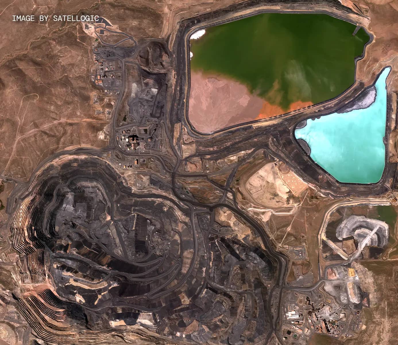
What benefits does SkyFi offer to the mining industry?
SkyFi offers multiple benefits to the mining industry, including resource identification, site mapping, environmental monitoring, safety monitoring, and production monitoring. Our satellite data helps streamline exploration processes, assess environmental impacts, detect safety hazards, and optimize production activities.
Improving Traffic Management with Satellite Imagery
Traffic congestion in urban areas is a persistent challenge. Traditional methods using surveillance cameras and ground sensors are often limited in scope. SkyFi offers a solution with satellite imagery, providing a comprehensive view of traffic flow. Our advanced object detection models can identify vehicles in real-time, enabling efficient traffic management.
By using satellite data, city planners can optimize traffic light synchronization and monitor traffic patterns over large areas. This approach reduces congestion and improves urban mobility without the need for extensive ground infrastructure.
Advancing Mineral Exploration
Mineral exploration is an essential yet complex task. SkyFi’s high-resolution satellite imagery simplifies this process by providing detailed spectral data. Our technology can identify specific minerals and geological formations from space, making it easier to locate potential mining sites.
Our satellite imagery enables geologists to analyze large areas quickly and accurately. This reduces the need for extensive ground surveys and allows for more precise targeting of exploration activities. The result is a more efficient and cost-effective approach to discovering valuable mineral resources.
Enhancing the Mining Industry
The mining industry benefits greatly from satellite imagery in several ways:
Resource Identification: Our satellite data helps pinpoint geological features associated with mineral deposits, streamlining the exploration process.
Site Mapping: Combining satellite images with geospatial tools allows for detailed mapping of mining sites, including topography and infrastructure.
Environmental Monitoring: Satellite imagery is crucial for assessing the environmental impact of mining activities. It helps track vegetation changes and identify sources of pollution, supporting sustainable practices.
Safety Monitoring: Our technology can detect potential safety hazards at mining sites, such as unstable slopes or hazardous substances, enabling proactive risk management.
Production Monitoring: Satellite data provides insights into the progress of mining operations, helping to optimize production and plan future activities.
The SkyFi Advantage
SkyFi’s platform offers seamless access to high-resolution satellite imagery and advanced analytics. Our solutions are designed to meet the diverse needs of industries, providing accurate and timely information for better decision-making.
With SkyFi, businesses can manage urban traffic, explore mineral resources, and enhance mining operations more effectively. Our commitment to providing cutting-edge Earth observation technology ensures that our clients stay ahead in their respective fields.
Embrace the Future with SkyFi’s Earth Observation Technology
SkyFi is dedicated to revolutionizing the way industries utilize satellite imagery. Our comprehensive data solutions empower businesses to make informed decisions and improve their operations. Join us in leveraging the power of Earth observation to create a smarter, more efficient, and sustainable future.