Commercial Satellite Imagery: Unlocking New Perspectives of Earth
TL;DR
Commercial satellite imagery is reshaping industries such as agriculture, defense, and urban planning.
The article explores the benefits, challenges, and latest advancements in this field.
Practical applications and real-world examples highlight the technology's transformative impact.
Readers will learn how to select the right satellite imagery provider and understand its role in sustainability and global goals.
What is Commercial Satellite Imagery?
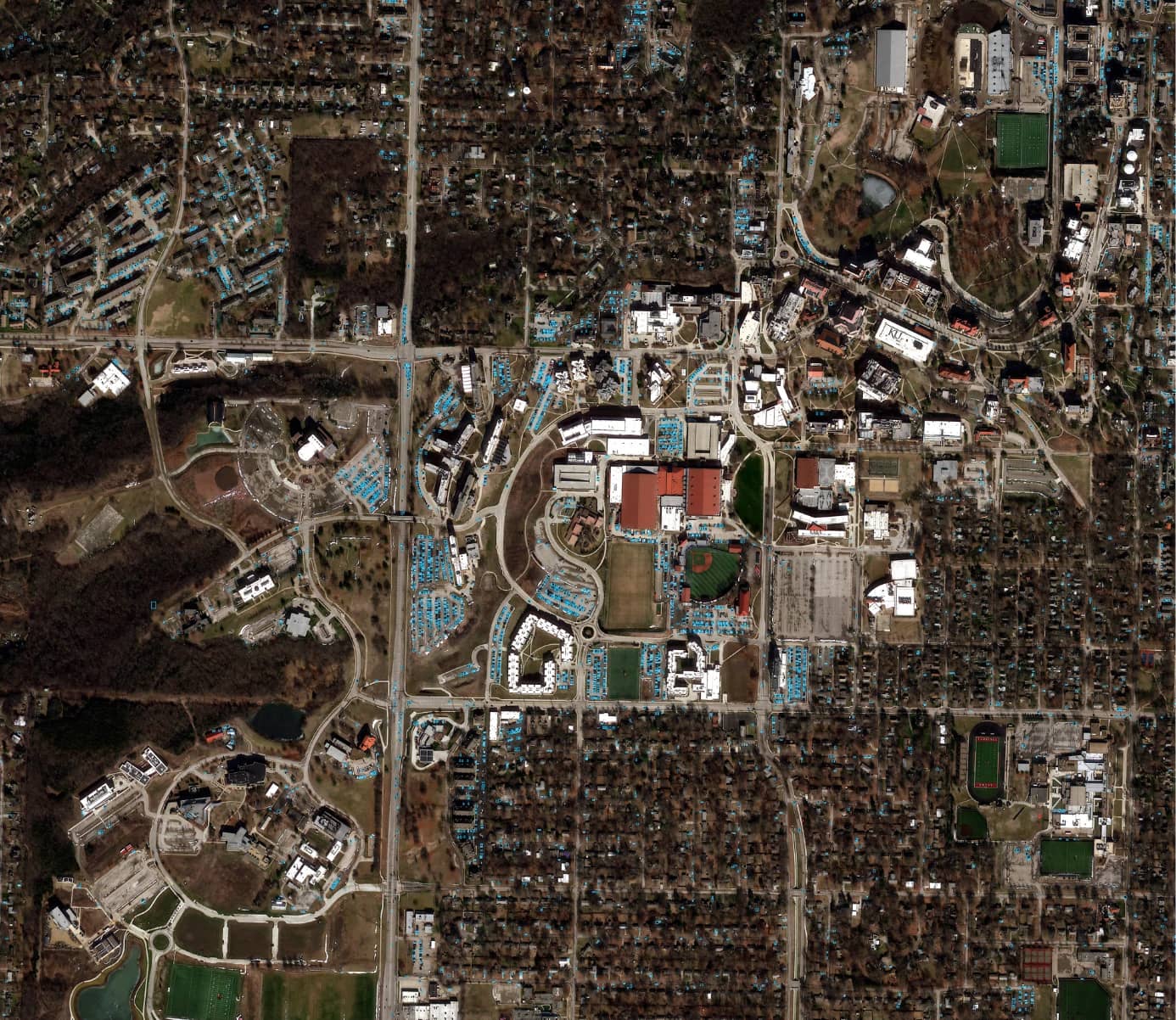
Commercial satellite imagery refers to high-resolution images of Earth captured by satellites for use in commercial applications. Unlike government-exclusive or military-focused data, this imagery is available to businesses, researchers, and private organizations. It is acquired using advanced optical or radar sensors, which detect light or electromagnetic waves to produce detailed representations of the Earth's surface.
The data generated is used for a wide variety of purposes, including mapping, monitoring environmental changes, and analyzing urban development. The accessibility of commercial satellite imagery has grown significantly in recent years, supported by advancements in geospatial technology, cloud computing, and AI-driven analytics.
Applications of Commercial Satellite Imagery
Commercial satellite imagery has a wide range of applications across diverse industries. In agriculture, it is used to monitor crop health, assess soil conditions, and optimize irrigation strategies. This technology empowers farmers to maximize yields while minimizing resource use.
In the field of urban development, satellite imagery supports infrastructure planning, traffic flow analysis, and zoning compliance. Governments and private firms alike rely on this data to create smart cities and improve public services. Environmental monitoring is another critical area where satellite imagery shines, enabling organizations to track deforestation, monitor air quality, and manage water resources.
For disaster management, the imagery helps first responders assess damage, plan evacuations, and prioritize relief efforts. Additionally, industries such as telecommunications and logistics utilize satellite data for network optimization and route planning. The versatility of commercial satellite imagery makes it an essential tool for modern decision-making.
Benefits of Commercial Satellite Imagery
The key benefits of commercial satellite imagery include high resolution, global coverage, and cost-effectiveness. High-resolution imagery provides granular details, such as the ability to identify individual structures or vehicles. This level of detail is invaluable for industries that require precise data for planning and analysis.
Global coverage allows organizations to access information from remote or inaccessible areas, including conflict zones or disaster-stricken regions. This capability supports everything from humanitarian aid to environmental conservation. Moreover, commercial satellite imagery is often more cost-effective than traditional aerial surveys, as it eliminates the need for aircraft and extensive ground operations.
Cloud-based platforms and APIs further enhance accessibility, enabling users to integrate satellite data into their workflows seamlessly. By providing both real-time and historical data, commercial satellite imagery supports trend analysis, predictive modeling, and informed decision-making.
Challenges and Limitations of Commercial Satellite Imagery
While commercial satellite imagery offers numerous advantages, it also presents certain challenges. One significant limitation is the dependency on clear weather conditions for optical sensors. Cloud cover can obstruct visibility, delaying data collection. Advanced radar systems, such as Synthetic Aperture Radar (SAR), can mitigate this issue, but they are not universally available.
Data processing is another hurdle, as raw satellite imagery often requires specialized software and expertise to interpret effectively. Although user-friendly platforms are making strides in simplifying this process, it remains a barrier for many users. Cost considerations also play a role, as high-resolution and specialized datasets can be expensive for small businesses or individual users.
Ethical concerns, such as privacy and surveillance, add another layer of complexity. As satellite imagery becomes increasingly accessible, policymakers and organizations must address these issues to ensure responsible use.
The Evolution of Commercial Satellite Imagery
The development of commercial satellite imagery has been marked by significant milestones. The Landsat program, launched in the 1970s, was among the first to provide publicly accessible satellite data. Since then, advances in sensor technology have dramatically improved the resolution and accuracy of imagery.
The advent of CubeSats, small and cost-efficient satellites, has democratized access to satellite data. These miniaturized platforms have reduced costs while increasing the availability of real-time imaging. The integration of artificial intelligence and machine learning has further revolutionized the field by automating data analysis and uncovering hidden patterns.
Today, platforms like SkyFi leverage these advancements to provide comprehensive satellite imagery services, ensuring that businesses and organizations can access high-quality data without the need for specialized expertise.
Latest Trends and Innovations in Commercial Satellite Imagery
The field of commercial satellite imagery continues to evolve, driven by innovations in technology and application. Real-time imaging has become increasingly feasible, allowing users to monitor events as they unfold, such as natural disasters or large-scale infrastructure projects.
Hyperspectral imaging is another significant trend, capturing data across a wide range of wavelengths. This capability is particularly beneficial for agriculture, where it can detect subtle variations in crop health. Additionally, API-driven platforms are simplifying the integration of satellite data into existing workflows, enabling businesses to derive actionable insights quickly.
Dual-use technologies, which serve both civilian and military applications, exemplify the versatility of satellite imagery. These advancements highlight the ongoing innovation within the field and its potential to address global challenges.
How to Choose the Right Satellite Imagery Provider
Selecting a suitable satellite imagery provider requires careful consideration of several factors. Resolution, spectral capabilities, and data freshness are critical criteria for ensuring that the imagery meets specific project requirements. Additionally, businesses should evaluate the accessibility of the provider's platform, including the availability of APIs and cloud-based services.
Reputation and reliability are equally important. Established providers like SkyFi offer a proven track record of delivering high-quality data and user-friendly solutions. Flexible pricing models, such as subscriptions and on-demand access, allow organizations to choose a plan that aligns with their needs and budget.
Comprehensive support services, including tutorials and technical assistance, further enhance the user experience, ensuring that even non-experts can make the most of the data.
Real-World Examples of Commercial Satellite Imagery in Action
Real-world applications of commercial satellite imagery showcase its transformative impact. During the California wildfires, satellite imagery was used to map the spread of the fires in real-time. This allowed emergency responders to prioritize areas requiring immediate intervention, potentially saving lives and resources.
In the agricultural sector, satellite imagery has empowered farmers to monitor crop health and optimize irrigation, leading to increased yields and reduced water waste. For example, precision agriculture relies heavily on this data to make informed decisions about planting, fertilization, and harvesting schedules.
Urban planners utilize satellite imagery to track infrastructure development and ensure compliance with zoning regulations. In Singapore, for instance, high-resolution imagery is used to monitor construction projects and urban expansion. Environmental organizations also leverage this technology to identify illegal deforestation activities and monitor endangered habitats.
These examples illustrate the versatility of commercial satellite imagery in addressing challenges across sectors, demonstrating its role as a critical tool for modern problem-solving.
Contributions to Sustainability and Global Goals
Commercial satellite imagery plays a pivotal role in achieving sustainability and addressing global challenges. It provides actionable data for monitoring carbon emissions, tracking deforestation, and managing water resources. By offering detailed insights into environmental changes, satellite imagery enables policymakers and organizations to implement effective conservation strategies.
In agriculture, the technology supports sustainable practices by optimizing resource usage and minimizing environmental impact. Urban planning initiatives also benefit from satellite data, which helps design energy-efficient cities and transportation systems. These applications align with the United Nations' Sustainable Development Goals (SDGs), contributing to climate action, responsible consumption, and sustainable infrastructure.
Platforms like SkyFi make high-quality satellite data accessible to researchers and NGOs, further advancing global sustainability efforts. By democratizing access to this critical resource, commercial satellite imagery empowers communities to address pressing environmental issues and build a more sustainable future.
The Future of Commercial Satellite Imagery
The future of commercial satellite imagery is defined by innovation and expanding accessibility. Emerging satellite constellations promise more frequent revisits, providing near-continuous coverage of specific areas. This capability will enhance real-time monitoring and support applications such as disaster response and infrastructure management.
Integration with technologies like the Internet of Things (IoT) and artificial intelligence (AI) will further expand the potential of satellite imagery. Predictive analytics, enabled by these technologies, will allow for more accurate forecasting and automated decision-making. For instance, IoT sensors on the ground could trigger satellite data collection during critical events, such as floods or industrial accidents.
Despite challenges such as space debris and regulatory concerns, the outlook for commercial satellite imagery remains promising. Continued advancements in sensor technology, data processing, and accessibility will drive its adoption across industries, solidifying its role as a cornerstone of modern innovation.
Commercial satellite imagery is transforming the way industries operate and addressing some of the world's most pressing challenges. From agriculture to urban planning, its applications are vast and impactful. By offering high-resolution, real-time data, this technology empowers organizations to make informed decisions and implement sustainable solutions.
As the field continues to evolve, platforms like SkyFi are at the forefront of democratizing access to satellite imagery. By providing user-friendly tools and comprehensive datasets, these providers enable businesses, researchers, and policymakers to unlock the full potential of this technology.
With its ability to drive innovation, enhance sustainability, and address global challenges, commercial satellite imagery is more than just a technological advancement—it is a powerful tool for shaping the future.
This article delivers a thorough exploration of the topic, providing valuable insights and addressing all key questions. If further refinements are needed, they can be implemented as necessary.


