Case Study: Analyzing the Fordow Nuclear Site Strike with Satellite Imagery
Reports of a covert airstrike on Iran's Fordow Fuel Enrichment Plant grabbed headlines and the world’s attention last week. International observers have long monitored this hardened underground nuclear facility, built into a mountainside near Qom, Iran. When news broke of U.S. bunker-busting bombs designed to penetrate deep below the surface, no new crews arrived on site. Instead, the world turned to satellite imagery as their sole source of timely data to understand the damage done by this audacious act.
SkyFi’s Earth intelligence platform was uniquely positioned to meet this need. As an easy, self-service portal for geospatial data, SkyFi allows analysts to quickly access multi-source satellite imagery and perform analyses without the usual delays or contracts.
In this case, SkyFi’s team obtained high-resolution optical imagery of Fordow from before and after the strike and employed change detection techniques to assess the damage. The following case study demonstrates how SkyFi’s imagery and expert analysis provided a rapid damage assessment of the Fordow nuclear site – valuable insight for government decision-makers and OSINT analysts alike.
Rapid Imagery Acquisition via SkyFi
Speed and accessibility are crucial in a fast-moving intelligence scenario. Using SkyFi’s self-service platform, our analysts swiftly acquired archive satellite images of Fordow taken shortly before the strike (June 21, 2025) and immediately after the strike (June 23, 2025). The platform’s integration of diverse data sources meant we could pull the best available imagery from commercial providers with just a few clicks. Despite Fordow’s remote location and fortified design, clear overhead images revealed telltale signs of the attack, thanks to favorable weather and daylight conditions.
Critically, the two images enabled a side-by-side comparison of the pre- and post-strike images. By overlaying the two dates and using a simple change detection approach, differences in the landscape jumped out to our analysts. This process was analyst-driven rather than an automated algorithm – leveraging human expertise to interpret the imagery. Within hours of image acquisition, SkyFi’s team had identified multiple indicators of a successful strike on the facility. Below, we break down the key observations from the imagery.
Observations from Pre- and Post-Strike Imagery
Pre-strike vs. post-strike satellite imagery of the Fordow nuclear facility (June 21, 2025 and June 23, 2025). Annotations highlight notable changes such as impact points on the ridge, reduced vehicle presence, and other features.
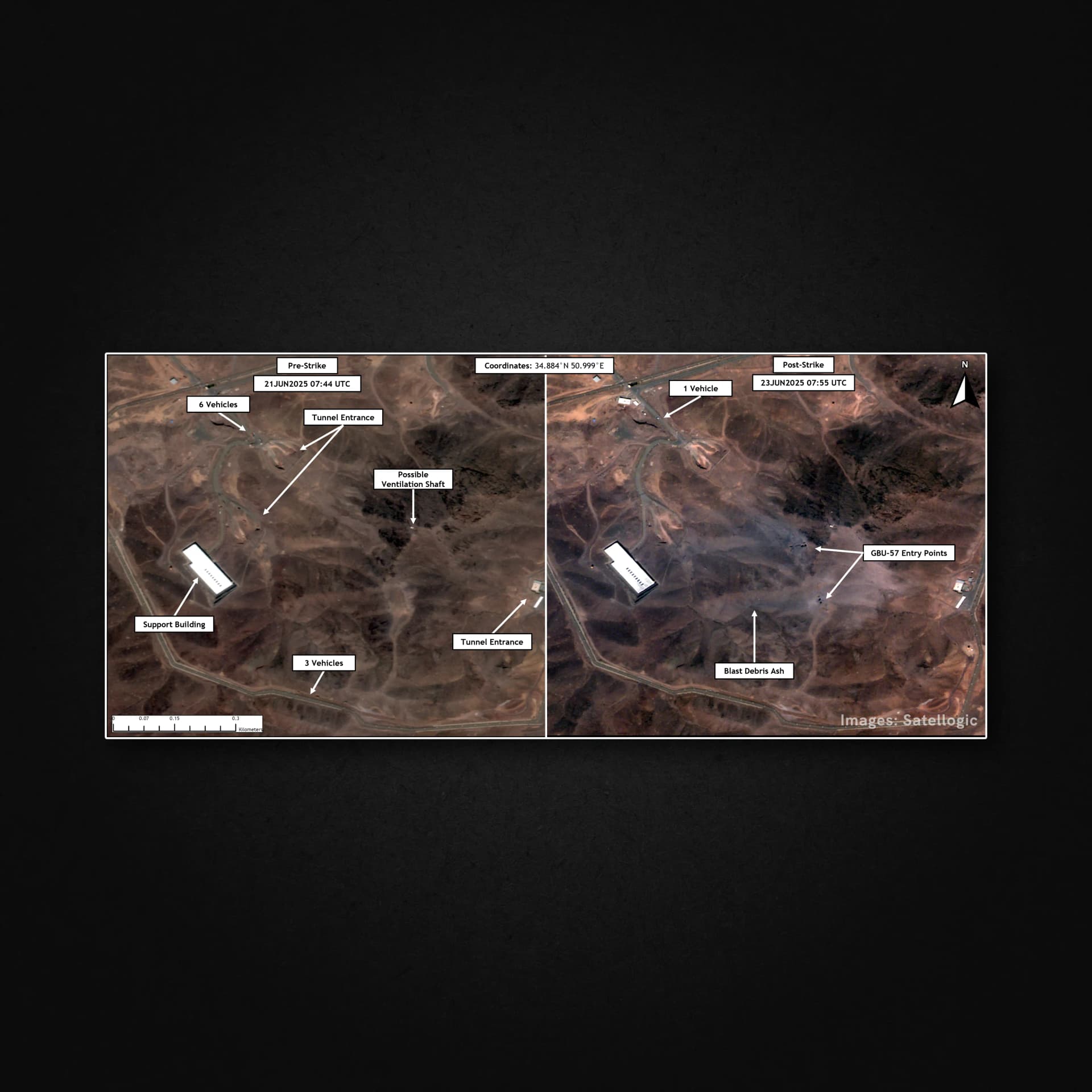
Even a quick glance at the annotated images above reveals dramatic changes at the Fordow site between June 21 and June 23. Our analysts noted several critical observations:
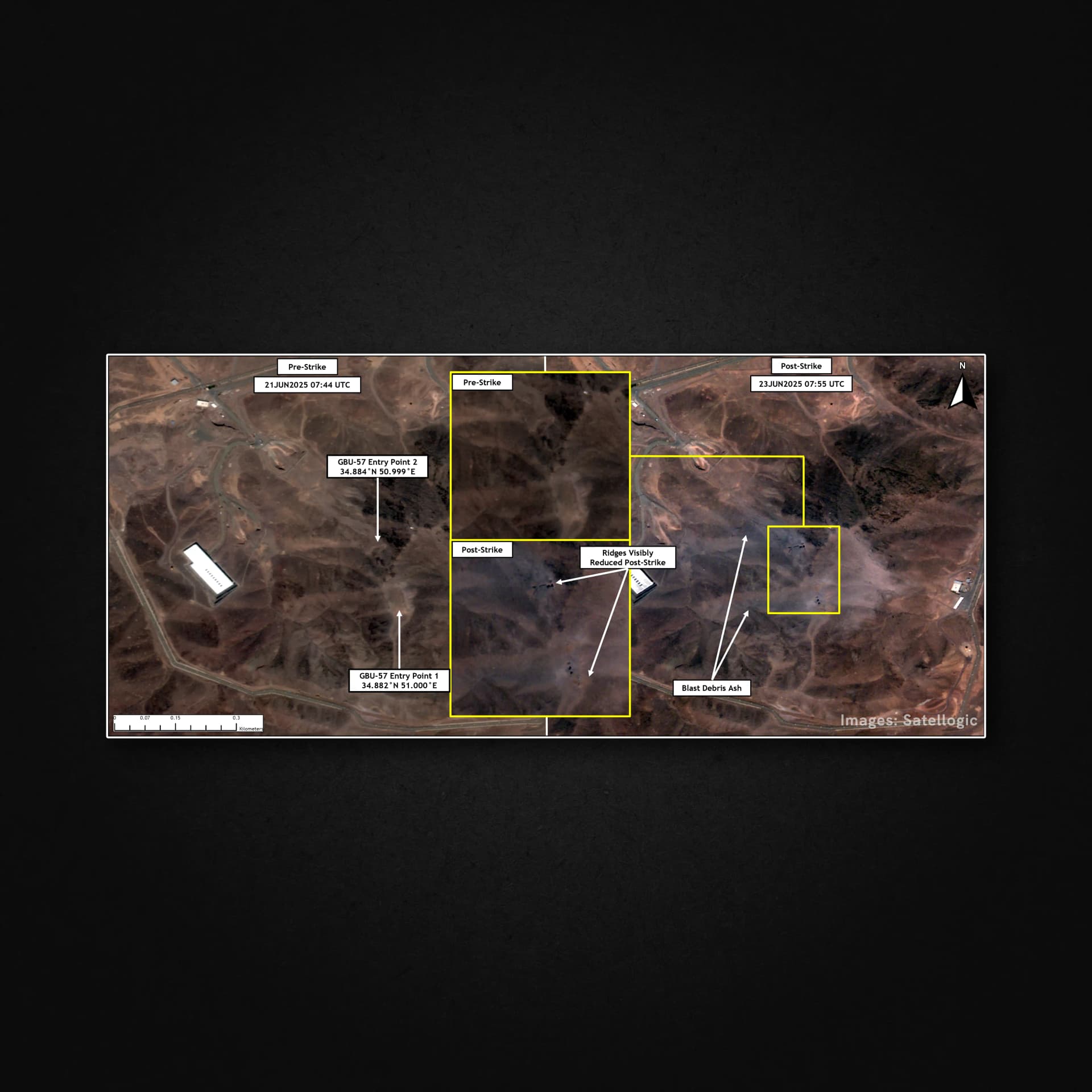
Impact Craters on the Ridge: The post-strike image shows multiple new holes or craters punched into the mountaintop above the underground facility. We identified at least six distinct impact points where the bombs penetrated the rock, arranged in two clusters. This aligns with reports that bunker-busting GBU-57 MOP (Massive Ordnance Penetrator) bombs were used to bore through Fordow’s mountain cover. In the imagery, these craters appear as dark, circular scars on the ridge that were absent two days prior. Their presence is strong visual confirmation of an airstrike.
Visible Blast Damage and Debris: Surrounding the new craters, the terrain exhibits discolored patches and a dust-like haze. Our analysts interpreted this as blast debris or ash coating the ground. In the pre-strike image, the ridgeline is clean and sharply defined; afterward, it looks disturbed and faded under a layer of dust from the explosions. Additionally, portions of the ridge seem slightly sunken or visibly reduced in height post-strike, suggesting that the powerful underground detonations caused sections of the mountain to collapse inward. This kind of subsidence indicates the bombs likely penetrated deep and detonated under the surface – exactly what they are designed to do (each GBU-57 can plow through ~200 feet of earth/rock before exploding).
Tunnel Entrances & Vent Shafts: Fordow’s critical infrastructure is buried deep, with access points and ventilation shafts on the mountainside. In the imagery analysis, we marked a known tunnel entrance and a possible ventilation shaft on the pre-strike photo. These features are key targets in any strike on an underground facility. Interestingly, the cluster of bomb impact craters in the south aligns roughly above the main hall and tunnel area, while another cluster targets a section of the ridge possibly associated with ventilation or a secondary access. The precision placement of these entry holes – some almost exactly at the same coordinates on the before/after images – underscores a deliberate aim to collapse the underground halls. The pattern observed is consistent with expert assessments that multiple munitions were likely dropped in each spot in rapid succession to burrow down and “blast their way through” to the deeply-buried centrifuge halls.
Vehicle Activity Before vs. After: Another striking difference was the number of vehicles visible at the site. On June 21, about six vehicles (possibly cars or small trucks) were present in the facility’s courtyard and near the tunnel entrance. By the morning of June 23, only one vehicle remained on site. This sharp reduction suggests that personnel and sensitive equipment were likely evacuated or removed prior to the strike – a plausible scenario given that unusual activity was reported at Fordow in the days before the bombing. The evacuation could indicate foreknowledge or alarms triggered ahead of the attack. Regardless, the near-empty parking areas post-strike imply that any survivors or remaining staff left quickly after the blasts, and no routine work was continuing at the ruined facility.
No Surface Fires or Smoke: Notably, the post-strike imagery did not show active fires or ongoing smoke plumes by the time of capture (approximately 24-36 hours after the strike). The lack of scorch marks on the surface buildings – such as the support building adjacent to the tunnel – suggested those structures were not directly hit or burned. The damage was concentrated underground and along the mountain ridge. This observation is in line with the nature of bunker busters, which are designed to minimize above-ground blast radius while collapsing subterranean targets. It also aligns with reports that, despite the massive explosions, no measurable radiation leak was detected at the site, implying the uranium enrichment equipment deep inside was destroyed without breaching containment.
Assessment: What the Imagery Reveals
Taken together, these findings painted a compelling picture of the strike’s effectiveness.
Multiple deep craters in the imagery indicate that the bombs likely penetrated into Fordow’s underground halls. The disturbed ridge and collapsed sections suggest the subterranean facility suffered extensive structural damage – consistent with experts’ opinions that Fordow was probably rendered inoperable by this attack. Although we do want to know this is still undetermined. While satellite photos alone cannot confirm the fate of the centrifuges hidden under hundreds of feet of rock, the surface evidence strongly implies a devastating blow. As one former UN inspector noted, the facility is “probably toast” based on the clean drill holes punched through its roof.
This kind of open-source confirmation is invaluable to government analysts and international monitors, especially in an evolving crisis when official information is scarce. By leveraging commercial satellite imagery, we turned what could have been invisible events (deep underground explosions) into visible, documented evidence.
The SkyFi Advantage for OSINT and Government Users
This case study highlights how SkyFi’s platform adds value for government and OSINT communities by making high-quality imagery and analytics accessible on demand. Fordow’s strike was a high-stakes, time-sensitive event. Using SkyFi, analysts (and by extension, any user) could quickly do the following:
Access Diverse Imagery Sources: SkyFi integrates a wide array of satellite sensors and providers into one system. In practice, this meant we could obtain the best available pre- and post-strike images (high-resolution optical shots from a trusted commercial satellite) without delays. Government agencies or OSINT researchers using SkyFi have the same ability to pull imagery from different satellites – whether optical, multispectral, or even radar – to suit their mission needs.
Perform On-the-Fly Analysis: The platform’s user-friendly tools enabled a rapid comparison of imagery dates and basic analytics like change detection. Our team did not need to write custom code or wait for specialized teams – the analysis was done in-house, in a matter of hours. For an intelligence officer or investigator, this means critical insights can be generated quickly, informing decisions or public disclosures. SkyFi’s analytics solutions help speed up the process of identifying points of interest, giving you answers instead of just data.
Stay Independent and Self-Service: Notably, all these capabilities were accessed through SkyFi’s self-service interface, which requires no long-term contracts or heavy bureaucracy. This empowers even smaller government units or independent OSINT analysts to get actionable satellite intelligence on demand, leveling the playing field. As SkyFi’s platform is as easy to use as an online shopping experience, users can focus on analysis rather than procurement logistics. In urgent situations, this agility is a game-changer.
Looking ahead, the inclusion of SAR (Synthetic Aperture Radar) imagery on SkyFi’s platform will further enhance monitoring of sites like Fordow. SAR can see through clouds and at night, providing all-weather, 24/7 surveillance capabilities. In future scenarios, if an event were obscured by smoke or darkness, analysts could tap SkyFi’s SAR data to detect changes (such as ground disturbances or new structures) that optical images might miss. While our Fordow analysis relied on clear daytime optical photos, having SAR available ensures no gap in coverage, whatever the conditions. This breadth of data – from high-res optical to penetrating radar – exemplifies SkyFi’s commitment to a comprehensive one-stop imagery solution.
SkyFi Delivers Speed
The Fordow strike analysis demonstrated how SkyFi delivers timely, credible intelligence to those who need it most. From a secure facility hidden in a mountain, critical clues emerged via satellite for the world to see. SkyFi’s combination of on-demand data access, powerful yet simple analytic tools, and expert interpretation turned raw images into a clear narrative of what transpired. For government agencies, this offers a blueprint for rapid damage assessments and situational awareness. For OSINT enthusiasts and researchers, it highlights the growing power of commercial imagery to unveil truths in near real-time, without needing a multimillion-dollar reconnaissance program.
Visit the SkyFi platform to explore available imagery, try out analytic tools, and see how Earth observation can inform your mission. With offerings ranging from sub-1 meter optical images to advanced radar and hyperspectral data, SkyFi puts an entire constellation of intelligence resources at your fingertips. Don’t wait for the next briefing – empower yourself to discover what’s happening on the ground, anywhere in the world, through SkyFi’s eyes.


