How Defense Satellite Imagery Revealed China’s First Nuclear-Powered Aircraft Carrier
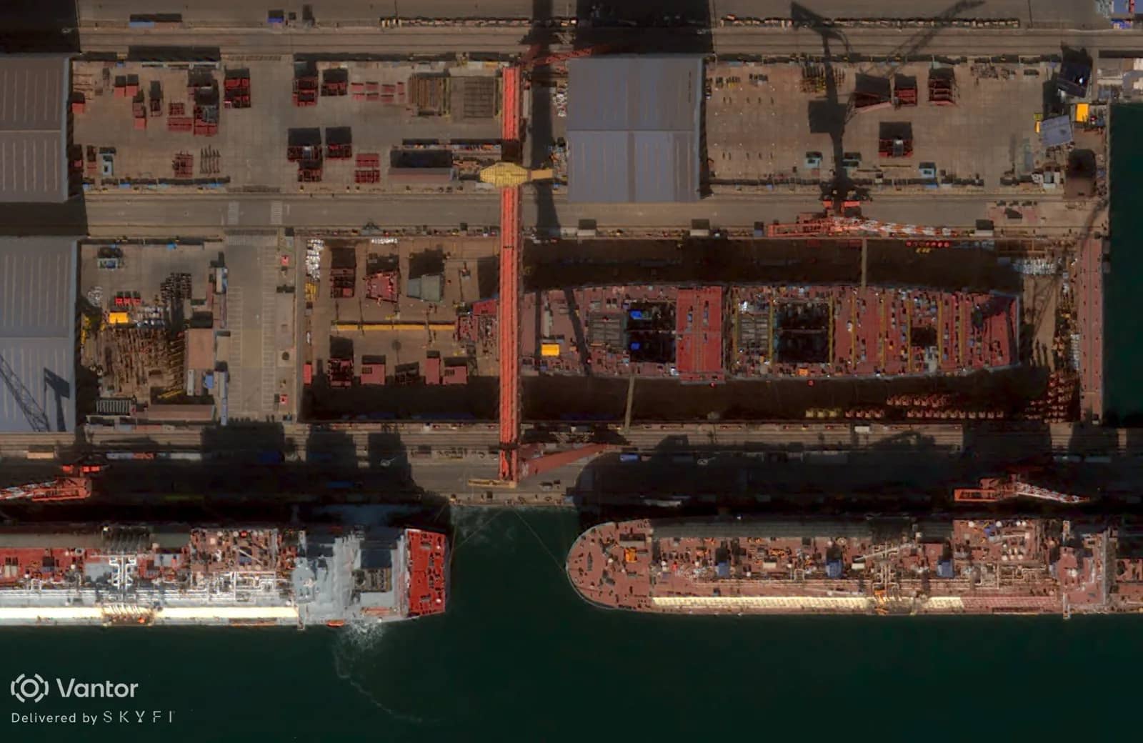
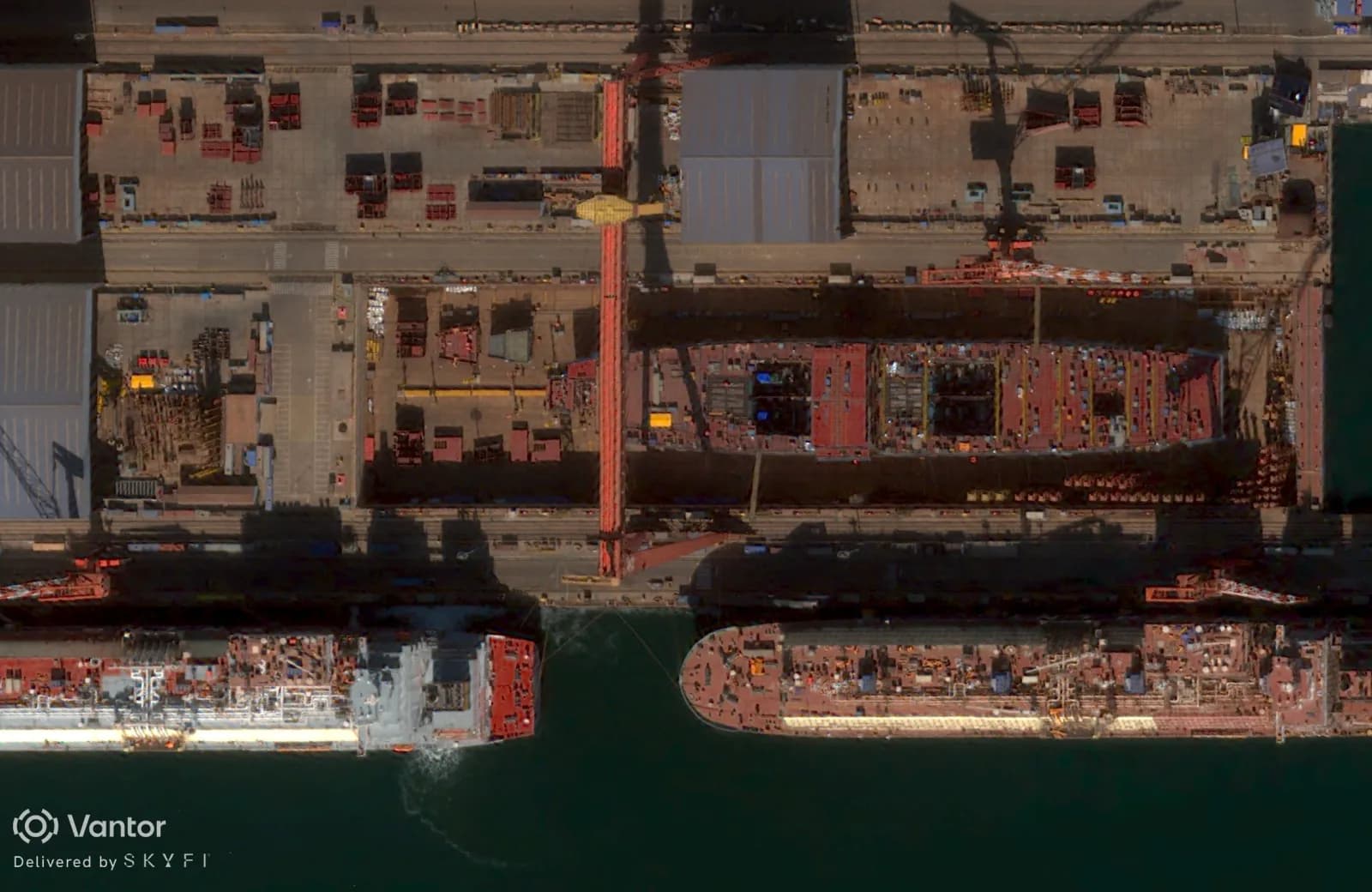
Defense satellite imagery is reshaping how the world monitors military buildups and few developments illustrate that shift more vividly than the construction of China’s Type 004 aircraft carrier. In February 2026, Vantor satellite imagery delivered by SkyFi was featured in a Newsweek article revealing visual evidence that China’s fourth carrier will be nuclear-powered. The images, acquired through SkyFi’s on-demand tasking platform, show reactor compartments and engine rooms taking shape inside the hull at Dalian shipyard in Liaoning province which were details that prompted multiple defense analysts to assess the vessel as almost certainly nuclear-propelled.
What Defense Satellite Imagery Shows at Dalian Shipyard
The Type 004 is under construction at the Dalian shipyard in Liaoning province, the same yard where China built the Shandong, its first domestically built aircraft carrier. Newsweek’s February 25, 2026 report by Micah McCartney relied on SkyFi-provided satellite imagery captured on February 17, 2026. In those images, analysts Tom Shugart and Frederik Van Lokeren said visible internal features strongly suggested the vessel is being built for nuclear propulsion, though Chinese officials have not publicly confirmed that assessment.
In the images, analysts identified what appear to be two shielded reactor compartments and as many as four engine rooms visible inside the open hull. Tom Shugart, a former U.S. Navy submariner and adjunct senior fellow at the Center for a New American Security (CNAS), assessed the imagery and noted strong parallels to early construction photographs of the U.S. Navy’s Ford-class carriers, which employ two nuclear reactors. Based on the build sequencing visible in the satellite imagery, Shugart estimated the Type 004 is at a stage roughly comparable to where the USS Enterprise was approximately two years into construction.
Reactor Compartments and Build Sequencing Visible from Space
Frederik Van Lokeren, a former Belgian naval officer and independent defense analyst, reached a similar conclusion after reviewing the SkyFi satellite imagery. He identified a raised rectangular section between two large square openings in the hull, one believed to be an engine room, the other likely reserved for reactor containment. Van Lokeren also pointed to indications that China may have acquired turbines rated for higher steam pressures than those powering the conventionally propelled Type 003 carrier Fujian, which entered service in November 2025.
The construction details like the reactor placement, engine room geometry, and turbine specifications are the kind of insights that defense satellite imagery enables at scale. Without persistent satellite monitoring, these assessments would depend entirely on sporadic leaks, official disclosures, or clandestine intelligence. Commercially available satellite data has changed that.
Comparing Type 004 Construction to U.S. Ford-Class Carriers
If the Type 004 is indeed nuclear-powered, China will join a club of only three nations operating nuclear carriers: the United States (11 active Nimitz- and Ford-class carriers) and France (the Charles de Gaulle). The construction parallels to America’s Ford class are notable. Both designs appear to use a two-reactor configuration but Chinese shipyards have demonstrated significantly faster build timelines. Analysts expect engine-room fitting and reactor containment installation to proceed in the coming months, well before the upper hull and flight deck are completed. Each of these milestones will be trackable through ongoing defense satellite imagery collection.
Why Defense Satellite Imagery Matters for Geospatial Intelligence
The Type 004 story illustrates a broader transformation in geospatial intelligence (GEOINT). What was once the exclusive domain of national intelligence agencies is now accessible to commercial analysts, investigative journalists, academic researchers, and private-sector decision-makers. Defense satellite imagery, delivered through platforms like SkyFi, enables persistent open-source monitoring of military infrastructure worldwide.
For GEOINT professionals, the value proposition is straightforward: the ability to task a satellite for a specific area of interest (AOI) on demand, receive high-resolution imagery within days, and order archive imagery to compare construction progress over time. This is exactly how Newsweek acquired imagery. A SkyFi user tasked a satellite to capture the Dalian shipyard, and the resulting images revealed construction details that multiple expert analysts confirmed as indicators of nuclear propulsion.
From Green-Water to Blue-Water: Tracking a Naval Shift
China already operates the world’s largest navy by hull count and is launching major combatants at roughly three times the pace of the United States. The addition of a nuclear-powered carrier would represent a significant step in Beijing’s long-stated ambition to transition from a “green-water” coastal defense force to a “blue-water” navy capable of sustained global operations.
Collin Koh, a senior fellow at Singapore’s Institute of Defence and Strategic Studies, has noted that the carrier buildup aligns with Beijing’s strategy of projecting power beyond the First Island Chain which is the arc of U.S.-allied territories that Washington considers vital to containing PLA Navy operations in a regional conflict. U.S. defense officials have assessed that China plans to field as many as nine carriers within a decade.
For organizations tracking these developments like defense agencies, think tanks, maritime insurers, and supply-chain risk managers, persistent access to defense satellite imagery provides an unmatched baseline for monitoring capability timelines and fleet readiness.
Nine Carriers in a Decade: What the Satellite Imagery Timeline Reveals
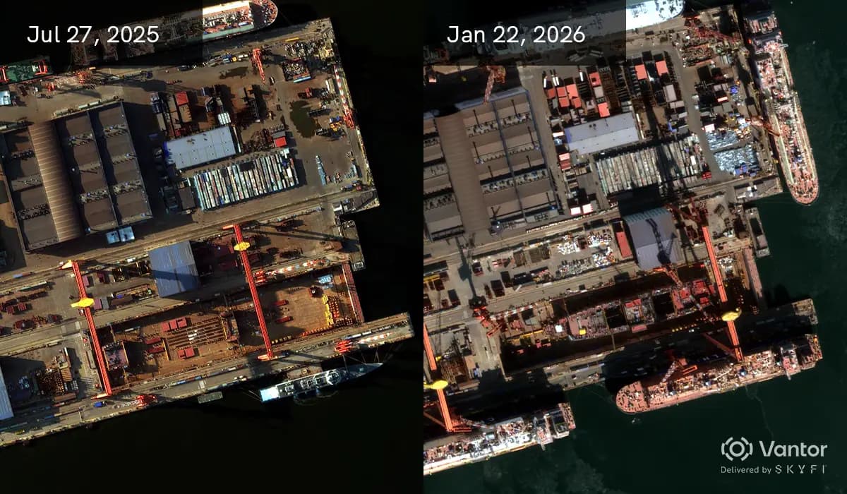
Satellite imagery archives allow analysts to reconstruct construction timelines with precision. By comparing historical captures of the Dalian and Jiangnan shipyards (where the Type 003 Fujian was built), researchers can benchmark Chinese build rates against Western equivalents and forecast commissioning windows. This kind of change detection analysis by comparing multiple image captures of the same site across months or years is one of the most powerful applications of commercial satellite data in the defense sector.
SkyFi’s archive search capability enables users to pull historical satellite imagery by date and location, making it possible to build these construction timelines without relying on classified sources.
How SkyFi Enables On-Demand Defense Satellite Imagery
The Newsweek investigation is a real-world example of how SkyFi’s platform translates commercial satellite capability into actionable geospatial intelligence. Here is how it works:
Satellite tasking. Users define an area of interest, select resolution and sensor requirements, set cloud-cover thresholds, and schedule an acquisition window. SkyFi routes the tasking request across multiple satellite providers to optimize for timing and image quality.
Multi-sensor access. The platform supports optical, synthetic aperture radar (SAR), hyperspectral, thermal, and aerial imagery. For maritime and defense use cases, SAR is particularly valuable because it captures usable imagery regardless of cloud cover or time of day. This is critical for persistent maritime SAR monitoring of shipyards and naval bases in regions with heavy cloud cover.
Archive search. Users can search SkyFi’s global archive by coordinates and date range to find historical imagery for change detection analysis.
Integrated analytics. Built-in tools for change detection, object detection, and classification let users extract insights directly on the platform without requiring external GIS software.
API integration. For enterprise and government customers who need to embed satellite data into existing intelligence workflows, SkyFi offers an API for programmatic tasking, search, and analytics.
Whether the use case is monitoring shipyard construction, tracking fleet movements, or assessing port activity, SkyFi consolidates the entire workflow from tasking through analysis into a single platform.
Frequently Asked Questions
What is defense satellite imagery?
Defense satellite imagery refers to satellite-captured images used for military and national security analysis. This includes monitoring military installations, tracking naval vessel construction and movements, assessing weapons development, and supporting battlefield awareness. While historically limited to government intelligence agencies, commercially available defense satellite imagery is now accessible through platforms like SkyFi, enabling open-source intelligence (OSINT) analysts, journalists, and private organizations to monitor global defense developments.
How is satellite imagery used for GEOINT?
Geospatial intelligence (GEOINT) combines satellite imagery with location-based analysis to produce actionable insights. Analysts use satellite imagery to detect changes at military facilities, identify equipment and vehicle types through object detection, monitor troop and naval movements, and assess infrastructure development. Modern GEOINT workflows leverage multi-sensor data: optical for visual detail, SAR for all-weather imaging, and thermal for heat-signature detection which often are accessed and processed through integrated platforms like SkyFi.
Can you task a satellite to monitor a specific military site?
Yes. Commercial satellite tasking allows users to request new imagery of a specific location within a defined time window. On SkyFi, users define their area of interest, choose a sensor type and resolution tier, and submit a tasking request that is routed across multiple satellite providers. This is exactly how the Dalian shipyard imagery featured in Newsweek was acquired, through SkyFi’s self-service tasking capability.
What sensors are used to monitor naval shipyards?
Optical sensors provide the highest visual detail and are ideal for identifying structural features like hull compartments and flight-deck geometry. Synthetic aperture radar (SAR) is essential for persistent monitoring because it operates through cloud cover and at night, making it particularly valuable for shipyards in regions like northeastern China where weather frequently obscures optical collection. Thermal sensors can detect heat signatures from welding or machinery operation. Combining multiple sensor types produces the most comprehensive intelligence picture.
How was SkyFi imagery used in the Newsweek investigation?
Newsweek’s February 2026 report on China’s Type 004 aircraft carrier was built around satellite imagery provided by SkyFi. The images, captured on February 17, 2026, showed reactor compartments and engine rooms inside the carrier hull at Dalian shipyard. Multiple defense analysts reviewed the SkyFi imagery and independently assessed that the vessel is almost certainly nuclear-powered. The investigation demonstrates how commercially available satellite data can support the same caliber of geospatial analysis that was once limited to classified intelligence.
References
McCartney, M. (2026, February 25). China’s first nuclear-powered aircraft carrier will challenge U.S. sea power. Newsweek. https://www.newsweek.com/chinas-first-nuclear-powered-aircraft-carrier-will-challenge-us-sea-power-11570665
Office of the Secretary of Defense. (2025). Annual report to Congress: Military and security developments involving the People’s Republic of China 2025. U.S. Department of Defense. https://media.defense.gov/2025/Dec/23/2003849070/-1/-1/1/ANNUAL-REPORT-TO-CONGRESS-MILITARY-AND-SECURITY-DEVELOPMENTS-INVOLVING-THE-PEOPLES-REPUBLIC-OF-CHINA-2025.PDF
Reuters. (2025, November 7). China’s third aircraft carrier, the Fujian, enters service. https://www.reuters.com/world/china/china-begins-commissioning-fujian-aircraft-carrier-2025-11-07/
U.S. Navy. (2025, February 27). Aircraft carriers (CVN). U.S. Navy Fact File. https://www.navy.mil/Resources/Fact-Files/Display-FactFiles/article/2169795/aircraft-carriers-cvn/
Kat Tungol is the Product Marketing Manager at SkyFi, with a background in remote sensing and professional training as a licensed geologist. She works at the intersection of geospatial science and product marketing, translating complex Earth observation capabilities into clear, practical value for users.