
Satellite Imagery Basemaps Now Available on SkyFi: 15 cm to 50 cm Vantor Vivid Mosaic
Every GIS workflow, mapping application, and geospatial analysis starts with the same foundational requirement: a reliable satellite imagery basemap. Without one, operational data layers lack geographic context, visualization suffers, and downstream analysis inherits the inaccuracies of whatever reference layer sits beneath it.
SkyFi now offers Vantor Vivid Mosaic basemaps directly through the platform, giving enterprise mapping teams, GIS professionals, and government agencies the ability to order seamless, high resolution satellite imagery basemaps the same way they already order archive imagery. Four resolution tiers are available on the app today, from 50 cm to 15 cm HD, with transparent per-square-kilometer pricing and 12-hour delivery.
What is a Satellite Imagery Basemap and Why Does it Matter?
Esri defines a basemap as "a foundational layer on a map that is the basis of GIS visual and geographic context." In practice, a satellite imagery basemap serves as the reference image on which all other data layers are stacked, from vector overlays and asset locations to analytical outputs and field observations.
A basemap is not the same as a raw satellite image strip. Individual archive scenes are captured at specific moments from specific orbits, which means they carry variations in lighting, cloud cover, off-nadir angle, and seasonal appearance. When you try to use raw strips as a visual base layer across a large area, the result is a patchwork of inconsistent tiles that creates confusion rather than clarity.
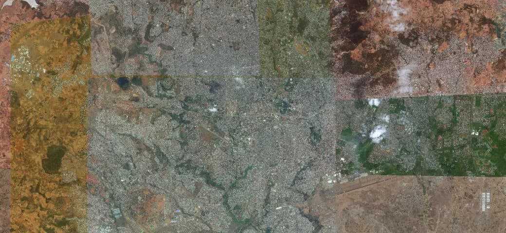

A satellite imagery basemap, such as the Vantor Vivid Mosaic, solves this problem. Hundreds of thousands of individual image strips are processed, color-balanced, and stitched together into a seamless, virtually cloud-free mosaic that looks and performs like a single continuous photograph of the Earth. That consistency is what makes basemaps essential for municipal planning, national mapping programs, infrastructure monitoring, and any GIS workflow that depends on reliable visual context across broad geographies.
Vantor Vivid Mosaic Basemaps: What SkyFi Now Offers
The Vantor Vivid Mosaic product line represents the most widely deployed commercial satellite imagery basemap available today. Vantor (formerly Maxar) produces these mosaics using imagery from its WorldView satellite constellation, and the resulting products are used by mapping platforms, defense agencies, and enterprise GIS teams worldwide. Mapbox, for example, recently integrated 10 million square kilometers of updated Vivid Mosaic 30 cm imagery into its mapping platform to improve coverage across population centers globally.
SkyFi now provides direct access to Vivid Mosaic basemaps through the same ordering interface used for archive imagery and satellite tasking. There is no separate procurement channel, no contract negotiation, and no minimum commitment beyond the order itself.
Core specifications across all Vivid Mosaic products available on SkyFi:
Positional accuracy: Better than 5 m CE90
Spectral bands: 3-band natural color (RGB) or 4-band (BGRN) including near-infrared
Image freshness: Imagery refreshed within 12 months
Coverage: Global landmass, excluding Antarctica
Minimum order: 1 km²
Delivery: 12 hours
The 4-band BGRN option is worth noting for teams that need near-infrared data for vegetation analysis, land classification, or environmental assessments alongside their basemap. This means a single product can serve as both the visual foundation layer and a functional input for basic spectral analysis.
Resolution Tiers and Pricing for High Resolution Satellite Imagery Basemaps
SkyFi offers four Vivid Mosaic products through the app, with two additional resolution tiers available by request. Each tier serves a different operational requirement and budget profile. Choosing the right one depends on the scale of your area of interest, the level of detail your workflow demands, and the features you need to identify on the ground.
Vivid Standard 50 cm: From $9 per km²
The 50 cm Vivid Standard basemap is the most cost-effective option for teams that need broad-area sub-meter coverage. At this resolution, you can clearly distinguish buildings, roads, large vehicles, agricultural field boundaries, and land use patterns. It is well suited for regional mapping, land administration, rural planning, and environmental monitoring projects where complete, gap-free coverage across a large area is more important than identifying small ground-level features.
For national mapping programs or organizations that need to cover thousands of square kilometers, the 50 cm basemaps deliver a consistent, accurate visual base at the lowest per-unit cost.

Vivid Standard 30 cm HD: From $12 per km²
The 30 cm HD product uses Vantor's proprietary HD processing to enhance visual clarity beyond the 50 cm tier, making features like individual vehicles, road markings, and small structures more distinguishable. For teams that need sharper detail than 50 cm provides but don't require the native 30 cm Advanced product, this tier offers a practical middle ground.
Vivid Advanced 30 cm: From $15 per km²
The Vivid Advanced 30 cm delivers native 30 cm resolution, meaning the detail comes directly from the sensor capture rather than from processing enhancement. At this level, you can clearly identify individual cars, narrow pathways, small outbuildings, and road lane markings. Vivid Mosaic at this tier is the world's first satellite imagery basemap to deliver near-seamless coverage at 30 cm across 135 million square kilometers of global landmass. Unlike the Standard 30 cm HD, the Advanced product is available in 4-band RGBN, which includes the near-infrared band. That fourth band is essential for teams running vegetation health analysis (NDVI), land use classification, or any spectral workflow that goes beyond natural color visualization. Native resolution also matters when your workflow depends on precise feature extraction, measurement accuracy, or analytical outputs that are sensitive to how the source imagery was produced.

Vivid Advanced 15 cm HD: From $15 per km²
The 15 cm HD basemap delivers the finest detail available in the Vivid Mosaic product line. At this resolution, you can identify road lane markings, utility lines, individual trees, building entrances, and small infrastructure features. Vantor provides over 7 million square kilometers of 15 cm HD coverage concentrated across the world's most populated and high-interest regions.
This tier is designed for municipal-scale operations where identifying individual features on the ground matters, including city planning, permit review, zoning enforcement, property assessment, and urban development monitoring.

1 m, 2 m, and 4 m Basemaps: Available Upon Request
For organizations that need cost-efficient coverage across very large areas, such as entire countries or continental landmasses, SkyFi also offers Vivid Mosaic basemaps at 1 m, 2 m, and 4m resolution. These are available upon request through skyfi.com and are well suited for national mapping agencies, NGOs, and programs where complete spatial coverage takes priority over high-resolution detail.
Use Cases for Satellite Imagery Basemaps
GIS and Enterprise Mapping Workflows
For GIS professionals working in ArcGIS, QGIS, or enterprise geospatial platforms, a satellite imagery basemap serves as the visual reference layer beneath every operational dataset. Vivid Mosaic products provide the geographic context needed for change detection, asset tracking, facility management, and portfolio-wide analysis across large areas. The 4-band BGRN option supports teams that need near-infrared capabilities for vegetation indices or land classification without purchasing a separate analytical dataset.
Because Vivid Mosaic imagery is orthorectified, it integrates cleanly into precision GIS environments where spatial alignment between layers is critical.
Municipal Planning and Governance
City planners and municipal agencies rely on current, high resolution satellite imagery for zoning decisions, permit review, land use management, and code enforcement. The 15 cm HD basemap provides the level of detail required to identify individual building footprints, road features, property boundaries, and construction activity at the parcel level.
Public-facing mapping portals also benefit from a visually consistent basemap that citizens and stakeholders can reference when engaging with planning documents, environmental impact assessments, or development proposals.
Infrastructure Monitoring and Construction
Construction firms, engineering consultancies, and asset operators use satellite imagery basemaps to establish visual baselines for pre-construction site assessment, progress documentation, and long-term change tracking. At 15 cm or 30 cm resolution, project managers can confirm site access routes, verify parcel boundaries, and document surrounding context without deploying field crews for every reference update.
For organizations managing distributed infrastructure portfolios across pipelines, transportation networks, or energy assets, a seamless basemap ensures that every facility and corridor is viewed within consistent, current geographic context.
National Mapping and Cadastral Programs
National mapping agencies and cadastral authorities need complete basemap coverage that is consistent in quality, accurate in positioning, and refreshed on a regular cadence. Vivid Mosaic's 30 cm global coverage supports census operations, boundary delineation, rural development planning, and land administration at national scale. The 50 cm and lower-resolution tiers provide additional cost efficiency for countries or regions where very high resolution detail is not required for mapping.
Why Order Satellite Imagery Basemaps Through SkyFi?
There are several ways to access Vantor Vivid Mosaic products, including directly through the Vantor Hub or through authorized resellers. SkyFi offers a distinct ordering experience designed around simplicity and speed.
Transparent, per-km² pricing. Every basemap product on SkyFi lists its price upfront. There are no subscription commitments, no volume negotiations, and no contract requirements. You pay per square kilometer for the area you need.
Low minimum order. The minimum order across all four resolution tiers is 1 km². This means individual analysts, small teams, and pilot projects can access the same basemap products that serve enterprise-scale deployments, without being forced into large-area commitments.
12-hour delivery. Orders placed through SkyFi are delivered within 12 hours or less. For teams that need basemap coverage on a project timeline rather than a procurement cycle, this turnaround eliminates a common bottleneck.
One platform for all your Earth observation data. SkyFi users already order archive satellite imagery, submit tasking requests, run geospatial analytics, and access multi-sensor data through a single interface. Basemaps are now part of that same workflow. There is no need to manage a separate vendor relationship, portal login, or procurement channel for your foundational image layer.
How to Order Satellite Imagery Basemaps on SkyFi
Ordering basemaps on SkyFi follows the same workflow you already use for archive imagery:
Navigate to the SkyFi explore page at app.skyfi.com/explore.
Click "Basemaps" to switch from the default archive view to the basemap catalog.
Define your area of interest (AOI) on the map and place your order.
Choose your product from the four available Vivid Mosaic options: Vivid Standard 50 cm, Vivid Standard 30 cm HD, Vivid Advanced 30 cm, or Vivid Advanced 15 cm HD.
Your basemap will be delivered within 12 hours. For 1 m, 2 m, and 4 m resolution basemaps, submit a request through skyfi.com
Frequently Asked Questions About Satellite Imagery Basemaps
What is the difference between a basemap and standard satellite imagery?
Standard satellite imagery consists of individual scenes captured during a single satellite pass. Each scene reflects the conditions at the moment of capture, including cloud cover, sun angle, and seasonal variation. A basemap is a processed mosaic that combines many individual scenes into a seamless, color-balanced, cloud-free image layer designed to serve as a consistent visual foundation for mapping and analysis. Basemaps prioritize visual continuity across large areas, while standard archive imagery preserves the temporal specificity of a particular capture date.
How often is Vantor Vivid Mosaic basemap imagery refreshed?
Vantor Vivid Mosaic basemaps are refreshed within a 12-month cycle. Vantor collects and processes over 50 million square kilometers of new mosaic imagery each year, prioritizing areas where significant ground-level change has occurred. This ensures that the basemap reflects current conditions across populated and high-interest regions.
What resolution basemap do I need for my project?
The right resolution depends on what you need to identify. At 50 cm, you can distinguish buildings, roads, and land use patterns. At 30 cm, individual vehicles and road markings become visible. At 15 cm, you can identify lane markings, utility infrastructure, and building entrances. If you need broad-area coverage for regional planning or national mapping, the 50 cm or 30 cm tiers offer the best balance of detail and cost. If you need parcel-level detail for municipal operations or infrastructure inspection, the 15 cm HD tier is the stronger choice.
Can I order basemaps through the SkyFi API?
The SkyFi API allows programmatic access to platform capabilities including imagery search, tasking, and order management. For API-based basemap ordering, contact SkyFi or read the SkyFi API documentation and integration details.
Andrew Canales is the Chief Revenue Officer at SkyFi, where he leads global go-to-market strategy and commercial growth, expanding customer access to satellite imagery and analytics through a seamless, scalable platform. Andrew brings more than two decades of experience in geospatial intelligence and defense technology. Prior to joining SkyFi, he spent over 22 years at Maxar Technologies, most recently serving as Vice President of Business Development supporting U.S. Government programs, and previously leading enterprise sales and global commercial initiatives. He has partnered with U.S. government agencies, defense primes, emerging technology companies, and Fortune 500 enterprises to drive growth and launch innovative products and programs.


