
Satellite Tasking Explained: How to Order Custom Satellite Imagery
When existing archive imagery doesn’t match your timeline, location, or sensor requirements, satellite tasking lets you order a new capture whenever you need it. Accurate near real-time imagery can be the key difference in optimizing workflow or making a deadline, so it is important that you find your desired satellite image for your industry.
Instead of settling for data that’s weeks or months old, you define the exact parameters such as area of interest, resolution, sensor type and cloud cover threshold. Then, a satellite operator schedules a dedicated collection pass over your area.
This guide breaks down how satellite tasking works, when it makes sense over archive purchases, what parameters drive cost and quality, and how platforms like SkyFi simplify the process by routing tasking requests across multiple satellite constellations from a single interface.
TL;DR (Too Long; Didn’t Read)
Satellite tasking lets you order a custom image capture by defining your area of interest, resolution, sensor type, and cloud cover threshold instead of relying on existing archive imagery.
Cost and quality depend on resolution, revisit rate, sensor type, and collection window, with SAR offering all-weather capability and optical delivering sharper visual detail.
SkyFi simplifies the process by routing requests across multiple satellite constellations through one platform, with transparent pricing starting at $300.
What Is Satellite Tasking?
Satellite tasking is the process of requesting a satellite operator to capture new imagery of a specific location within a defined time window. Unlike purchasing archive imagery, where you browse a catalog of previously collected scenes, tasking satellites gives you control over when, where, and how the data is acquired.
A tasking order typically specifies an area of interest (AOI), the desired resolution, acceptable cloud cover percentage, the sensor modality (optical, SAR, or multispectral), and the acquisition window. The operator then schedules the collection into the satellite’s orbit plan and delivers the data once it’s captured and processed.
Satellite image tasking has historically been limited to government agencies and military commands with direct operator relationships and six-figure budgets. That has changed. The rapid expansion of commercial constellations from operators like Vantor, Planet, Satellogic, Umbra, ICEYE, and others has driven down costs and opened satellite imagery to a much wider market, including enterprise teams, insurers, financial services, agricultural analysts, and infrastructure operators.
The Evolution of Satellite Image Tasking
The concept of tasking for satellite images, and satellite imagery as a whole, has evolved tremendously over the years. The following is a chronological timeline of how this occurred:
Pre-1972: Satellites were used solely for military reconnaissance, with no systems in place for civilian or commercial image collection.
1984: Satellite imagery was first commercialized, introducing the concept of ordering satellite imagery for non-military purposes, though funding limitations slowed adoption.
1992: The Land Remote Sensing Policy Act allowed private companies to launch and operate imaging satellites, laying the groundwork for commercial satellite imagery tasking as a viable industry.
Post-1992: Earth observation satellites with increasingly precise sensors made it possible to task satellite imagery over specific areas of interest for environmental monitoring, disaster response, land mapping, and more.
Today: A constellation of 2,200+ satellites from commercial and government operators worldwide supports on-demand tasking, giving users the ability to direct satellites to capture imagery of virtually any location on Earth.
Satellite Tasking vs. Archive Imagery: When You Need a New Capture
Not every project requires a custom satellite image capture. Archive imagery is faster to deliver, often cheaper, and perfectly adequate when timeliness isn’t critical. The decision comes down to four factors:
Recency: If you need imagery from the last 24–72 hours and nothing recent exists in the archive, tasking is the only option.
Specificity: Tasking lets you define exact AOI boundaries, off-nadir angles, and sensor parameters that archive scenes may not cover.
Repeatability: Monitoring campaigns like construction progress, crop cycles and environmental compliance require scheduled repeat captures at consistent intervals.
Sensor availability: If you need Synthetic Aperture Radar (SAR) data for a region where the archive has only optical coverage, tasking a radar satellite is the path forward.
For one-off analysis of a well-covered region, start with the archive. For anything time-sensitive, site-specific, or requiring repeat coverage, satellite tasking is the right approach.
How Does Satellite Tasking Work?
The satellite tasking workflow for requesting a custom capture follows a consistent pattern across providers, though the procurement complexity, specific interface (if any) and pricing models vary.
Define Your Area of Interest
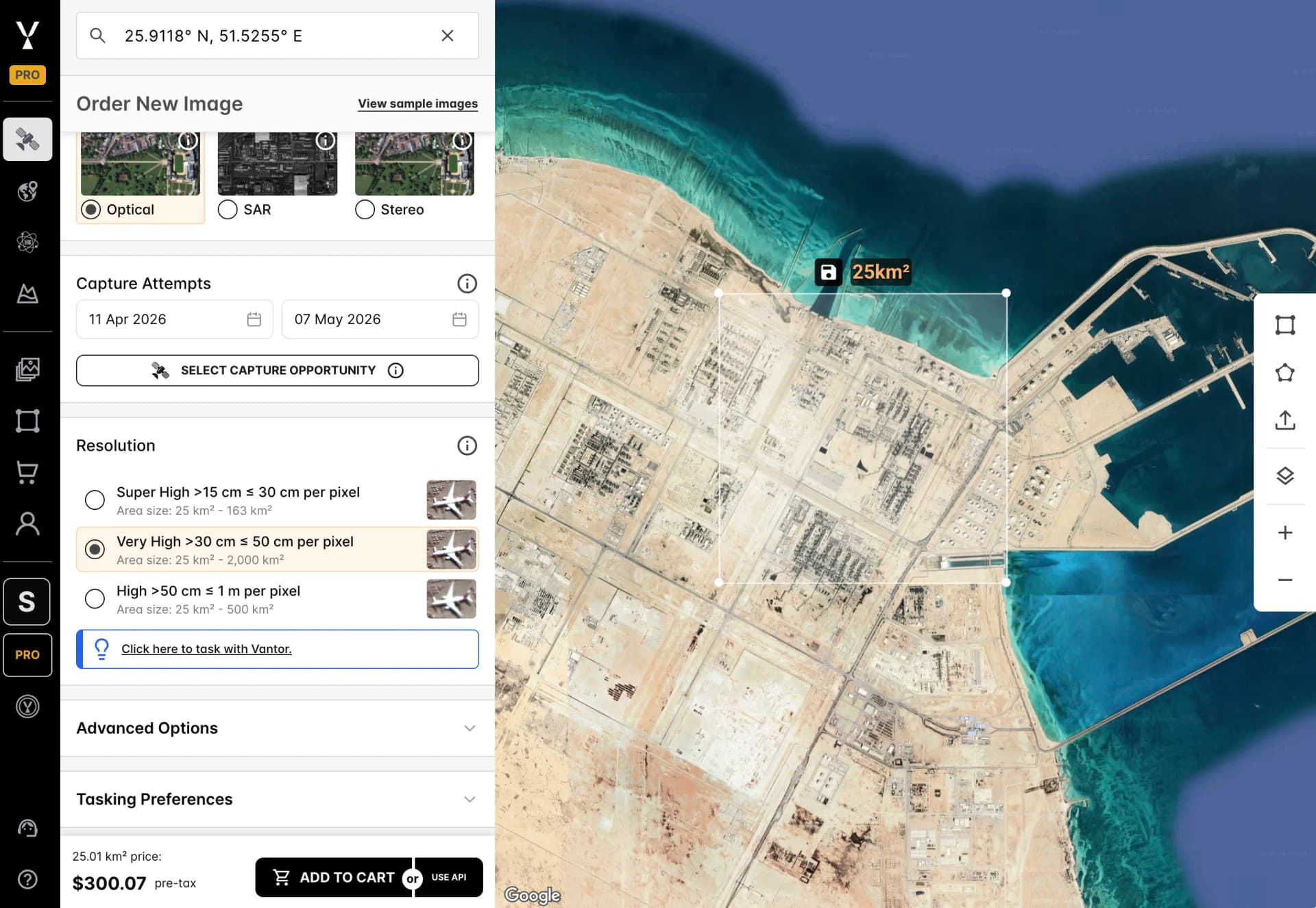
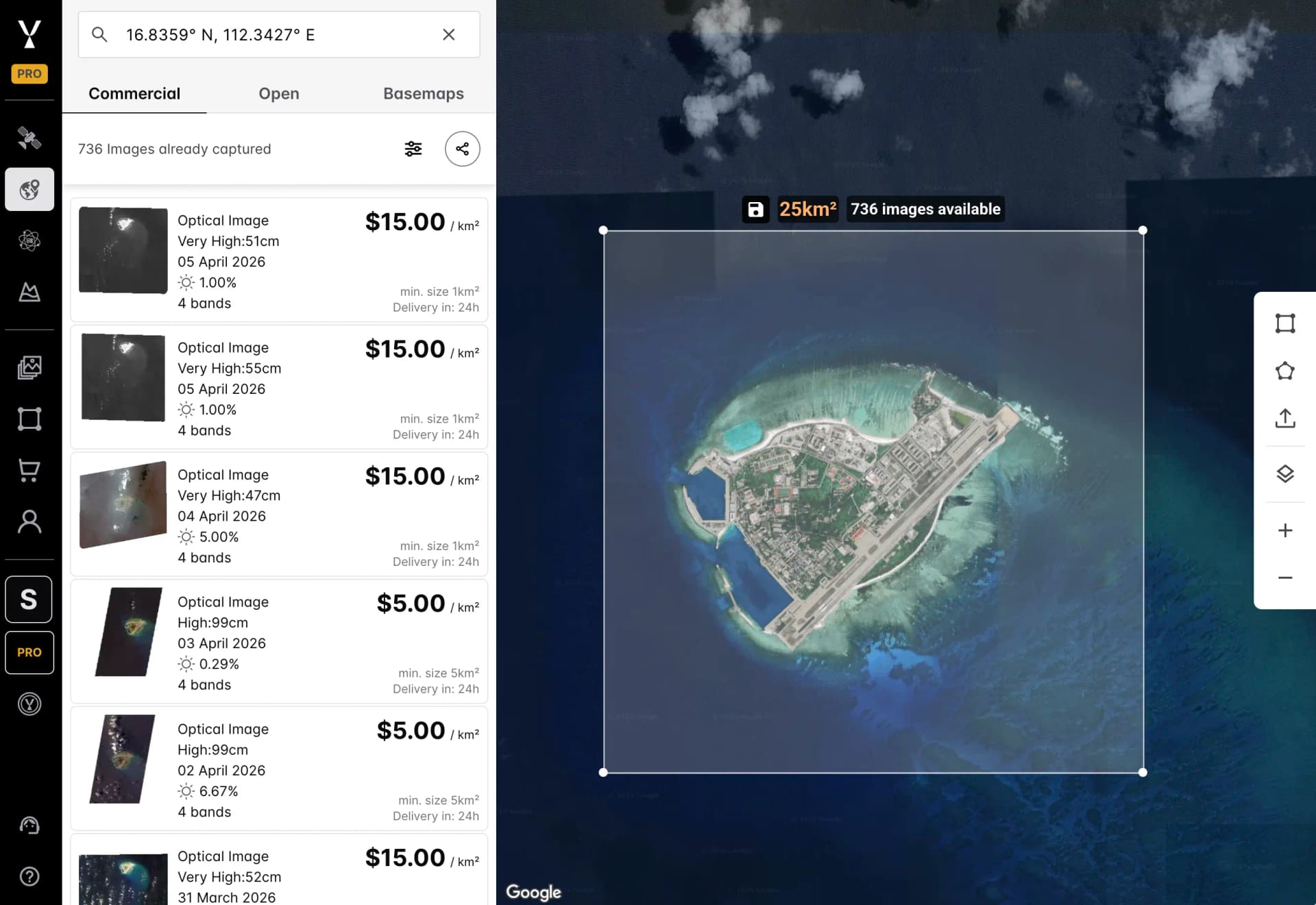
Every order for satellite imagery starts with an AOI, which is the geographic boundary of what you want captured. Most satellite tasking platforms accept a polygon drawn on a map, a GeoJSON file, or a KML upload. AOI size directly affects cost: larger areas require more collection time and may span multiple satellite passes.
For most commercial use cases, AOIs range from a few square kilometers (a single construction site) to hundreds of square kilometers (a regional agricultural zone).
Select Sensor Type and Resolution
The sensor you choose determines what information the satellite imagery captures. Optical sensors deliver natural-color or multispectral imagery at resolutions from 30 cm to several meters. SAR sensors operate through cloud cover and at night, making them essential for persistent monitoring in tropical or high-latitude regions. Multispectral sensors capture multiple spectral bands for material identification and vegetation analysis.
Resolution requirements depend on your use case. Sub-meter resolution (below 1 m) is necessary for identifying individual vehicles, structural damage, or small-scale construction activity. Imagery at 1–5 m resolution suits agricultural monitoring, land-use classification, and broad infrastructure mapping.
Set Cloud Cover and Timing Parameters
For optical high-resolution satellite imagery tasking, cloud cover is the primary risk factor. You’ll set a maximum acceptable cloud cover percentage that typically ranges from 10% to 20% for analytical work. The tighter the threshold, the longer it may take to fulfill the order, because the satellite may need multiple passes before conditions are clear. SAR tasking avoids this constraint entirely, since radar penetrates clouds.
Timing parameters include the acquisition window (the date range within which the capture must occur) and, in some cases, a preferred time of day. Shorter windows and priority scheduling increase cost but guarantee faster delivery.
Key Satellite Tasking Parameters That Affect Cost and Quality
Satellite Imagery Resolution
Resolution defines how much detail satellite imagery captures, measured by the real-world size of each pixel. This is technically known as ground sample distance (GSD). A 30 cm resolution image means each pixel represents a 30 cm × 30 cm area on the ground.
Higher resolution (smaller pixel size) costs more per square kilometer but reveals more information from finer detail. The highest commercially available optical resolution from satellites as of April 2026 is 30 cm from providers like Vantor (formerly Maxar).
Satellite Revisit Rate and Collection Windows
The satellite revisit rate is how frequently a given satellite or constellation can image the same location. This determines how quickly a tasking order can be fulfilled and how often you can collect repeat imagery.
Single-satellite operators may revisit a target every 3–5 days. Large constellations like Planet’s SkySat fleet or Satellogic’s constellation can achieve daily revisits.
For monitoring campaigns, revisit rate is as important as resolution. A weekly construction progress report requires reliable revisit cadence, not just sharp imagery. Platforms that route tasking across multiple constellations rather than locking you into a single operator maximize your chances of hitting collection windows on schedule.
Optical vs. SAR Satellite Tasking
Optical tasking delivers the imagery most teams are familiar with: natural-color or multispectral scenes best suited for visual interpretation and spectral analysis. The limitation is weather, specifically dark clouds that block optical sensors entirely.
SAR tasking uses microwave radar pulses that penetrate clouds, smoke, and darkness. SAR imagery looks different from optical (it renders surfaces as grayscale based on radar backscatter), but it’s useful for all-weather monitoring, subsidence detection, maritime surveillance, and change detection in persistently cloudy regions.
Many operational workflows combine both. They use SAR for guaranteed collection frequency and optical for detailed visual analysis when skies are clear.
Common Satellite Tasking Use Cases
Construction and Infrastructure Monitoring
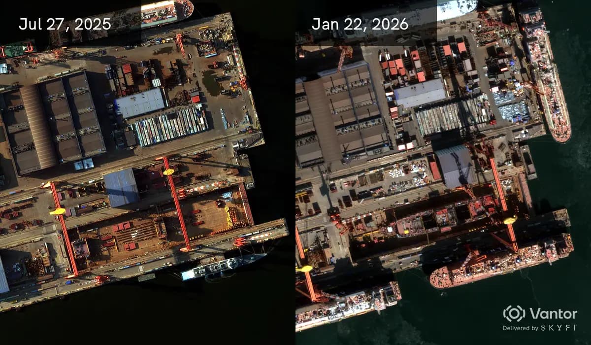
Construction firms, project owners, and lenders use satellite tasking to track site progress at regular intervals. Bi-weekly or monthly captures at sub-meter resolution document land changes, structural progress, equipment mobilization, and site access changes, without sending teams into the field.
Change detection analytics applied to sequential captures automate progress reporting and flag deviations from project plans.
Disaster Response
After natural disasters like floods, earthquakes, hurricanes, and wildfires, emergency responders need current imagery within hours, not days. Satellite tasking with priority scheduling can deliver post-event captures within 24-48 hours.
SAR tasking is especially critical here, since disasters often occur during cloudy weather that blocks optical sensors. Organizations like FEMA, the International Charter, and insurance rapid-response teams rely on tasked satellite imagery for damage assessment and resource allocation.
Defense and Intelligence
Government and defense analysts use satellite imagery tasking for persistent surveillance, activity monitoring, and change detection at strategic sites. Tasking parameters in defense contexts often include specific off-nadir angles, stereo pair collection for 3D terrain modeling, and strict delivery timelines.
Platforms that support secure ordering workflows and cleared data handling are essential for classified or sensitive missions.
Agriculture and Environmental Monitoring
Agronomists and environmental scientists task satellites for seasonal crop health assessments, irrigation monitoring, deforestation tracking, and compliance verification. Multispectral imagery with NDVI analysis reveals vegetation stress invisible to the naked eye. Monitoring campaigns with regular revisit schedules provide the temporal density needed to track growth cycles or detect illegal land clearing over time.
How to Choose a Satellite Tasking Provider
The satellite imagery tasking market includes both direct operators (companies that own and operate satellites) and aggregation or marketplace platforms (companies that provide access to multiple operators through a unified interface). Choosing between them depends on your requirements:
Single-operator access: this works if you know exactly which constellation you need and have the volume to justify a direct contract. You get more control over that operator's specific parameters, but most operators require order minimums, lengthy sales cycles, and custom contracts. You're also locked into a single constellation's revisit schedule, sensor type, and coverage gaps, with no fallback if weather or orbit timing delays your collection.
Multi-provider platforms: works for aggregate tasking across constellations, giving you access to multiple sensor types, resolutions, and revisit rates from a single order interface. This approach maximizes collection probability, eliminates the need for multiple vendor relationships, and simplifies procurement. If one operator can't fulfill your window, the platform routes to another with no additional contracts or sales calls required.
Key evaluation criteria include transparent pricing (avoid platforms that require a quote for every order), API availability for programmatic tasking, support for monitoring campaigns, and cloud delivery to AWS S3, Google Cloud Storage, or Azure.
SkyFi operates as a multi-provider satellite tasking platform, routing requests across optical, SAR, multispectral and aerial constellations. Users configure tasking parameters through the web platform, mobile app, or API and the system handles provider selection (if not selected), scheduling, and delivery.
For teams that need both archive access and custom captures across sensor types, a unified platform eliminates the complexity of managing multiple operator relationships.
Satellite Tasking FAQs
How much does satellite image tasking cost?
Tasking costs vary based on resolution, sensor type, priority level, and area size. SkyFi’s pricing plans for one-time satellite image purchases include separate plans for optical and SAR tasking.
Optical tasking at 50 cm resolution starts at $300 for a 25 km² area. At 30 cm resolution, orders start at around $812 for 25 km². Priority and guaranteed-collection cost more but offer faster turnaround and higher collection assurance.
SAR tasking is priced per scene, starting at $675 for a 5 km x 5 km scene. SkyFi displays satellite tasking pricing transparently in the platform, so you can compare options before committing to an order.
How long does a satellite tasking order take to fulfill?
Standard tasking orders are typically fulfilled within 3–14 days, depending on the satellite’s orbit, weather conditions (for optical), and the size of the collection window you specify. Priority tasking can reduce this to 24-72 hours for constellations with high revisit rates. SAR tasking tends to be faster on average because cloud cover isn’t a blocking factor.
Can you task a satellite to capture imagery at night?
Yes, with SAR sensors. Synthetic aperture radar is an active sensor that emits its own microwave signal, so it operates independently of sunlight.
Optical sensors require solar illumination and cannot collect usable satellite imagery at night. If your monitoring requirements include nighttime collection, SAR tasking is the appropriate choice.
What is the highest resolution available through satellite image tasking?
The highest commercially available optical resolution is approximately 30 cm, offered by operators like Vantor (formerly Maxar). SAR resolution varies by mode, with spotlight modes achieving sub-50 cm in some commercial systems.
Resolution requirements should be matched to the analysis task as higher resolution isn’t always necessary and significantly increases data volume and cost.
What is the difference between satellite tasking and satellite monitoring?
Satellite tasking refers to a single collection request for a specific time window. Satellite monitoring is a series of tasking orders scheduled at regular intervals that could be weekly, bi-weekly, or monthly, to track changes over time.
Most satellite tasking platforms, including SkyFi, support monitoring campaigns as a configured workflow rather than requiring you to submit individual tasking orders repeatedly.
Start Ordering Satellite Imagery & Custom Captures
Satellite tasking puts precise, timely Earth observation data within reach of any organization that needs more than what archive imagery provides. Whether you’re tracking construction milestones, responding to a natural disaster, monitoring agricultural zones, or building intelligence products, the ability to task a satellite on demand across multiple constellations and sensor types is now operationally and financially accessible.
SkyFi’s satellite tasking platform makes satellite imagery tasking straightforward. Simply define your AOI, set your parameters, and let the system route your request to the best-fit constellation.
Explore SkyFi’s satellite tasking services at app.skyfi.com, or integrate custom satellite captures directly into your workflows via the SkyFi API.


