High-Resolution Satellite Imagery: The Complete Guide for 2026
High-resolution satellite imagery refers to Earth observation data captured at a ground sampling distance (GSD) of 1 meter or less per pixel. At this level of detail, individual buildings, vehicles, tree canopies, and infrastructure become clearly visible from space. The highest commercially available resolution today reaches 30 centimeters per pixel, which is sharp enough to distinguish a sedan from a pickup truck or identify the type of aircraft parked on a runway.
This guide covers everything you need to know about high-resolution satellite imagery in 2026: how resolution is measured, what the different tiers look like in practice, which providers and satellites deliver each level of detail, and how to actually order and access this data for your projects.
What Makes Satellite Imagery "High Resolution"?
Resolution in satellite imagery is measured by ground sampling distance (GSD). It is the real-world size of area that a single pixel represents. An image with a 50cm GSD means each pixel covers a 50cm × 50cm area on the ground
The industry generally divides satellite imagery into four resolution categories:
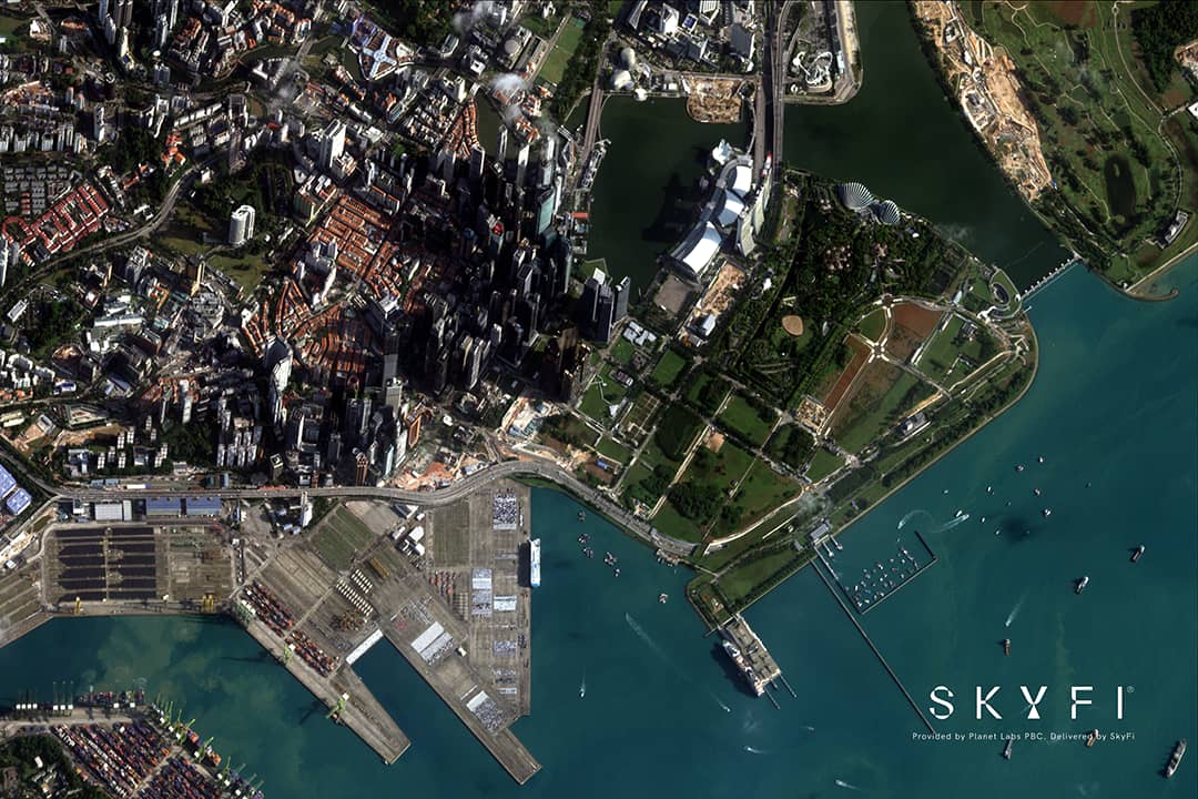
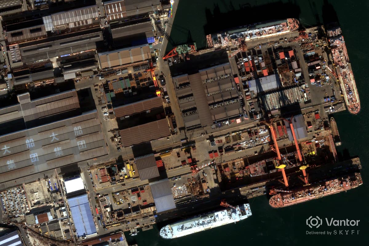
Very High Resolution (VHR): 30cm – 50cm GSD. Individual vehicles, building footprints, road markings, and small structures are clearly identifiable. This is the tier used for defense intelligence, urban planning, detailed asset monitoring, and insurance damage assessment. Satellites operating at this level include Vantor's WorldView Legion (30cm) and Planet's Pelican constellation (30cm).
High Resolution (HR): 50cm – 1m GSD. Buildings, roads, large vehicles, agricultural field boundaries, and land use patterns are visible. This tier serves most commercial applications including agriculture monitoring, environmental assessments, infrastructure mapping, and construction tracking. Planet SkySat (50cm) and Satellogic (70cm–1m) operate in this range. Medium Resolution: 1m – 30m GSD. Broad land cover classification, regional vegetation health monitoring, and large-scale environmental change detection. Sentinel-2 (10m) and Landsat 9 (15–30m) are the most widely used sensors at this tier, and both offer free, open-access data. Low Resolution: 30m+. Weather monitoring, ocean and atmospheric studies, and global-scale analysis. Useful for research but not for identifying specific features on the ground. MODIS (Moderate Resolution Imaging Spectroradiometer) satellite imagery sits here at 250m resolution.
When people search for "high-resolution satellite imagery," they typically need data in the VHR or HR categories to reach sub-meter resolution where individual objects and structures are distinguishable. 15 cm HD is also available in the market from Vantor which is native 30 cm imagery with Vantor's proprietary HD technology applied.
What Can You Actually See at Each Resolution?
Resolution specs are abstract until you understand what they look like in practice. Here's a practical breakdown of what becomes visible at each tier.
30cm Resolution
At 30 centimeters per pixel, this is the sharpest commercially available satellite imagery. You can identify vehicle types (car vs. truck vs. bus), count individual cars in a parking lot, see road lane markings, distinguish between types of aircraft at an airfield, identify rooftop equipment like HVAC units, detect construction staging areas with individual material piles, and read large ground-painted markings.
This resolution tier is essential for defense and intelligence analysis, detailed insurance damage assessments after natural disasters, and precision infrastructure inspection. Providers like Vantor (WorldView Legion) have 30cm satellite imagery commercially available.
50cm Resolution
At half a meter per pixel, you can clearly identify individual buildings and their shapes, detect vehicles (though not distinguish types as easily), see swimming pools, tennis courts, and similar residential features, map road networks with lane-level precision, identify crop rows in agricultural fields, and track construction progress at building sites.
This is ideal for most commercial applications. It provides enough detail for site monitoring, property assessment, urban mapping, and agricultural management without the cost premium of 30cm data. Planet SkySat operates at this resolution. High-resolution satellite imagery from Planet can be tasked and ordered on-demand.

1m Resolution
At one meter per pixel, you can identify buildings, roads, and major infrastructure, see large vehicles and equipment, classify land use (residential vs. commercial vs. industrial), map forest coverage and deforestation boundaries, detect flood extent and large-scale damage, and monitor mining operations and large construction sites.
One-meter imagery balances detail with coverage area and cost. It's widely used for environmental monitoring, municipal planning, disaster response mapping, and broad-area change detection.
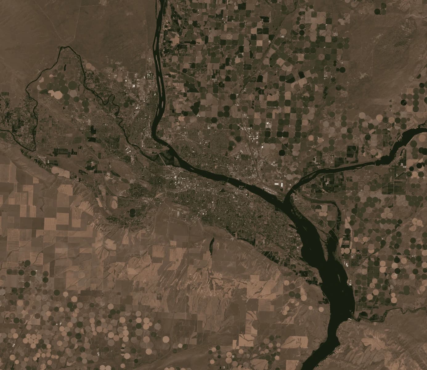
2–5m Resolution
At two to five meters per pixel, you can distinguish between land cover types (urban, forest, water, agriculture), identify large structures like factory complexes and airports, map road networks (though not individual lanes), track seasonal vegetation changes, and monitor large-scale agricultural health using multispectral bands.
This tier is commonly used for regional analysis, agricultural monitoring across large farm operations, and environmental studies where broad coverage matters more than fine detail.
10–30m Resolution (Free / Open Data)
Sentinel-2 at 10m and Landsat 9 at 15-30m offer free, globally available imagery. At this resolution, you can classify broad land use categories, monitor vegetation health across regions using NDVI, detect large-scale environmental changes (deforestation, urbanization, flooding), and track seasonal patterns and crop cycles across provinces or states.
This data is freely available through programs like ESA's Copernicus Data Space Ecosystem and USGS EarthExplorer. While it lacks the detail for site-level analysis, it provides an excellent baseline for regional monitoring and serves as a starting point before purchasing commercial high-resolution data for specific areas of interest.
Optical vs. SAR: Two Approaches to High-Resolution Imaging
Most discussions of satellite imagery focus on optical sensors which capture reflected sunlight, producing images that look like aerial photographs. However, Synthetic Aperture Radar (SAR) is also an imaging alternative that has been increasingly utilized in various sectors.
Optical Imagery
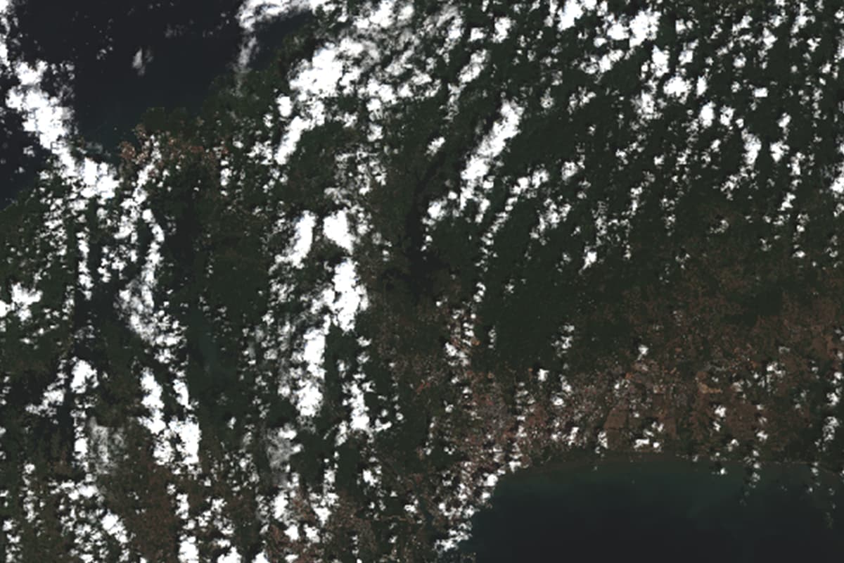
Optical sensors capture visible and near-infrared light. The resulting imagery is intuitive to interpret and it looks like what you'd see from a drone or an airplane. Optical data is ideal for visual identification, mapping, spectral analysis (vegetation health, water quality), and any application where natural color or multispectral information matters. The limitation is that optical sensors require sunlight and clear skies. Cloud cover, smoke, haze, darkness, and heavy rain all degrade or block optical imagery entirely. In tropical regions, persistent cloud cover can make it difficult to obtain usable optical imagery for weeks at a time.
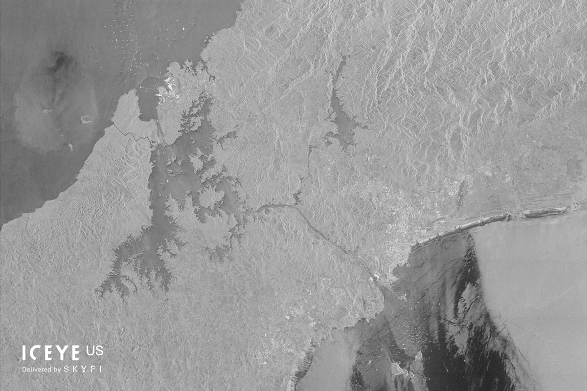
SAR Imagery
SAR satellites emit their own radar signal and measure the reflected energy. This means SAR works day or night, through clouds, smoke, fog, rain, and dust. SAR data looks different from optical imagery as it shows surface texture and structure rather than color but it provides information that optical sensors cannot.
SAR is essential for maritime monitoring (vessels are highly reflective to radar), flood mapping (water appears dark against land), infrastructure deformation detection (InSAR can measure millimeter-level ground movement), and any monitoring requirement in persistently cloudy regions.
The highest commercially available SAR resolution reaches 25cm from ICEYE and Umbra. Through SkyFi, users can access SAR data from ICEYE and Umbra alongside optical satellite imagery from multiple providers on a single platform without separate contracts.
When to Use Each
For most projects, the answer is "both." Optical imagery provides intuitive visual context and spectral analysis capability. SAR provides guaranteed collection regardless of weather or time of day. Many intelligence, defense, and environmental monitoring projects combine optical and SAR data to build a more complete picture than either sensor type can provide alone.
How High-Resolution Satellite Imagery Is Used Across Industries
Defense and Intelligence
Military and intelligence organizations rely on very high-resolution satellite imagery (30–50cm) for monitoring military installations and force movements, tracking naval vessel activity at ports and in open water, assessing infrastructure damage after strikes, identifying weapons systems and military equipment, and supporting border security and treaty verification. The ability to task satellites on short notice and receive imagery within hours — rather than days or weeks — has transformed operational intelligence workflows.
Agriculture and Precision Farming
Satellite imagery has become a standard tool in modern agriculture. Multispectral data at 3–5m resolution enables NDVI analysis to monitor crop health across entire farm operations. Higher-resolution data (sub-meter) supports field boundary delineation, irrigation system assessment, individual crop row analysis, and yield estimation. Satellite data also supports crop insurance verification, where imagery provides objective evidence of planting dates, crop health over time, and damage from weather events.
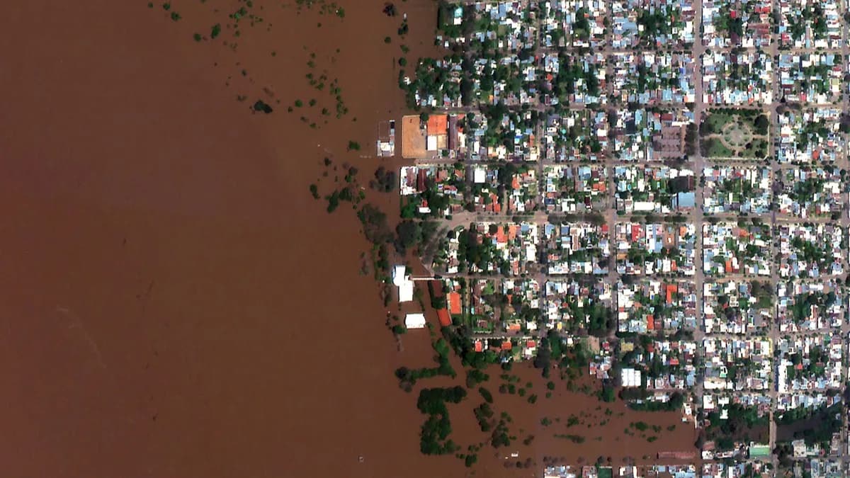
Disaster Response and Emergency Management
During natural disasters, satellite imagery provides critical situational awareness when ground access is limited or impossible. SAR imagery penetrates the smoke from wildfires and the clouds surrounding hurricanes to reveal damage that optical sensors cannot see. High-resolution optical imagery taken before and after an event enables rapid damage assessment such as comparing building footprints, road conditions, and flood extent against baseline data.
Urban Planning and Infrastructure
City planners use satellite imagery to monitor urban expansion, classify land use, and plan infrastructure development. A lot of infrastructure and real estate companies monitor construction progress remotely. Utility companies monitor pipeline corridors and power line rights-of-way. At sub-meter resolution, individual buildings, parking areas, and green spaces can be mapped and measured.
Environmental Monitoring
Deforestation tracking, glacier retreat measurement, coastal erosion monitoring, and pollution detection all rely on satellite imagery. Multispectral and hyperspectral data reveal environmental changes that are invisible to the naked eye. Stressed vegetation before it visibly wilts, water pollution plumes, and subtle shifts in land cover over time are some impactful environmental use cases for satellite imagery.
Financial Services and Insurance
Hedge funds and investment firms use satellite data to monitor economic activity indicators: counting cars in retail parking lots, tracking oil storage tank levels, measuring construction activity, and observing shipping traffic. Insurance companies use pre- and post-event imagery for claims verification and risk assessment.
Free vs. Commercial High-Resolution Satellite Imagery
One of the most common questions is whether free satellite images can replace commercial imagery. The answer depends entirely on your resolution and timeliness requirements.
What Free Data Offers
The best freely available satellite imagery comes from two main sources: Sentinel-1 and 2 (European Space Agency): 10m multispectral imagery with a 5-day revisit cycle. Excellent for regional vegetation monitoring, land cover classification, and broad environmental analysis. Available through Copernicus Data Space Ecosystem.
Landsat 9 (USGS/NASA): 15m panchromatic and 30m multispectral imagery with a 16-day revisit cycle. The longest continuous Earth observation archive (dating to 1972), invaluable for long-term change analysis. Available through USGS EarthExplorer.
SkyFi provides access to free satellite imagery from the European Space Agency within the platform, allowing users to start with free imagery and upgrade to commercial resolution only where the project demands it.
Where Commercial Data Becomes Necessary
Free satellite data works well for regional-scale monitoring, research, and initial reconnaissance. However, when you need to identify specific objects (vehicles, equipment, small structures), assess damage to individual buildings, monitor a specific site at high frequency, capture imagery on a specific date (tasking), or obtain imagery at sub-meter resolution for any purpose, commercial high-resolution satellite imagery is required. The gap between 10m (free) and 30cm (commercial) is large in practical terms where the difference is between seeing that a neighborhood exists and seeing individual houses, driveways, and vehicles within it.
Cost Considerations
Commercial satellite imagery pricing varies by resolution, sensor type, area covered, and whether you're ordering archive data or tasking a satellite for a new capture. Archive imagery (previously captured) is typically less expensive than new tasking. Lower resolution data costs less per square kilometer than very higher resolution data.
Through SkyFi, users can purchase commercial imagery starting at $25 with no minimum order commitments, long-term contracts, or subscription requirements. This pay-as-you-go model makes high-resolution satellite data accessible for one-time projects, small organizations, and individual researchers who would be priced out of traditional enterprise procurement.
How to Order High-Resolution Satellite Imagery
Traditionally, purchasing satellite imagery required contacting providers directly, negotiating contracts, and managing separate relationships with each data source. This process could take weeks and typically required large minimum purchase commitments. Modern geospatial platforms have streamlined this significantly. Through SkyFi, the process works in three steps.
Step 1: Define your area of interest. Draw a polygon on the map or upload geospatial files of the location you need imagery of. The platform shows you what's available from free open data to the highest-resolution commercial options.
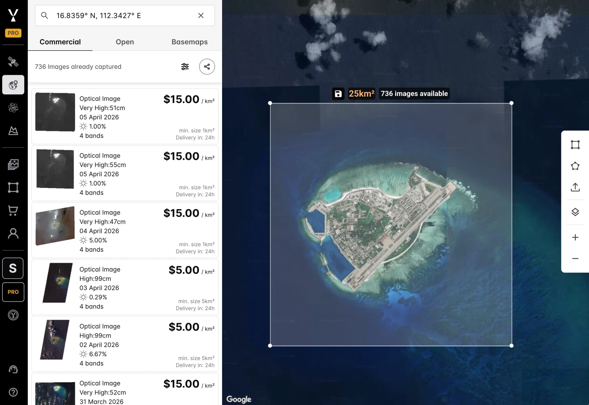
Step 2: Choose your imagery. Browse archive data captured previously or task a satellite to capture new imagery on a future date. Filter by resolution, sensor type (optical, SAR, multispectral), date range, and cloud cover. Pricing is displayed upfront for every option.
Step 3: Order and download. Add imagery to your cart, check out, and receive your data via email and within your SkyFi account. Archive imagery typically delivers within hours. New tasking orders are fulfilled based on satellite scheduling, with estimated delivery timelines provided at checkout. SkyFi aggregates imagery from over 50 satellite and geospatial analytics providers into a single platform, including Vantor, Planet, Satellogic, Umbra, ICEYE US, and others. This means you can compare and order imagery across providers without managing separate accounts or contracts.
Choosing the Right Resolution for Your Project
More resolution is not always better. Higher resolution imagery costs more per square kilometer, covers a smaller area per scene, produces larger file sizes, and may be unnecessary for your analytical requirements. The goal is to match resolution to your specific use case.
Use 30cm when you need to identify vehicle types, count objects, read ground markings, or conduct detailed intelligence analysis of specific facilities.
Use 50cm when you need to identify individual buildings, track construction progress, map properties, or conduct agricultural analysis at the field level. This resolution offers the best balance of detail and cost for most commercial applications.
Use 1-3m when you need to monitor land use, map infrastructure networks, assess flood extent, track deforestation, or conduct environmental analysis across large areas.
Use 5-10m (free) when you need regional vegetation monitoring, broad land cover classification, seasonal change tracking, or initial reconnaissance before ordering commercial data for specific sites.
Use SAR (any resolution) when you need guaranteed collection regardless of weather or time of day, maritime monitoring, flood mapping, or infrastructure deformation measurement.
The Future of High-Resolution Satellite Imagery
Several trends are reshaping the industry. New constellations launching in 2025-2027 are pushing commercial resolution below 30cm while dramatically increasing revisit rates. AI-powered analytics are increasingly embedded into imagery platforms, enabling automated object detection, change detection, and anomaly alerting directly from satellite feeds. Hyperspectral sensors are moving from niche research tools to operational commercial capability, adding chemical and material identification to the analytical toolkit.
Perhaps most significantly, the barriers to access are falling. What once required million-dollar contracts and specialized GIS expertise can now be accomplished through a mobile app. The democratization of satellite imagery means that the technology is no longer reserved for governments and large enterprises. It's now available to anyone with a specific question about a specific place on Earth.
Sources:
Mikkel Rasmussen is a Senior Remote Sensing Specialist at SkyFi, where he develops image processing methods, derived-data prototypes, and geospatial workflows that support scalable Earth observation products. With more than a decade of experience working across commercial and open-source satellite imagery, he collaborates closely with engineering, product, and UX teams to ensure efficient, operationally sound geospatial platforms.


