Satellite Imagery of the Iran Strikes: How SkyFi Partners Are Showing the World What's Happening
Since the U.S. and Israel launched Operation Epic Fury against Iran on February 28, 2026, the world has been watching the conflict unfold not through embedded reporters on the ground, but through the lenses of commercial satellites orbiting hundreds of miles above the Earth.
Before-and-after satellite imagery has become the definitive record of this conflict's scope and impact. From the destruction of Ayatollah Ali Khamenei's compound in central Tehran to collapsed missile tunnels in northwestern Iran to Iran's largest warship burning at port, commercial satellite providers are giving journalists, analysts, governments, and the public an unfiltered view of what is happening on the ground.
What many people don't realize is that the satellite imagery appearing on the front pages of the world's most respected news outlets comes from a handful of commercial providers, and that the same data is available to anyone. Through SkyFi's Earth Intelligence Platform, users can access imagery from the very same satellite constellations that Reuters, the Associated Press, NPR, the Washington Post, the New York Times, Business Insider, Newsweek, and dozens of other outlets are relying on to cover this conflict.
Here is how SkyFi's partners are shaping the world's understanding of the Iran strikes, and how you can order satellite imagery from those same constellations today.
The Imagery Making Headlines: What Satellites Are Revealing
Within hours of the first strikes on February 28, commercial satellite imagery began appearing across global media, providing independently verifiable evidence of the campaign's scope, targets, and cascading regional impact. The imagery is being sourced almost entirely from providers that are SkyFi partners, meaning the same satellite constellations powering the world's top newsrooms are available to anyone through SkyFi's satellite imagery marketplace.
Here are five of the most significant satellite images from the conflict, and who captured them.
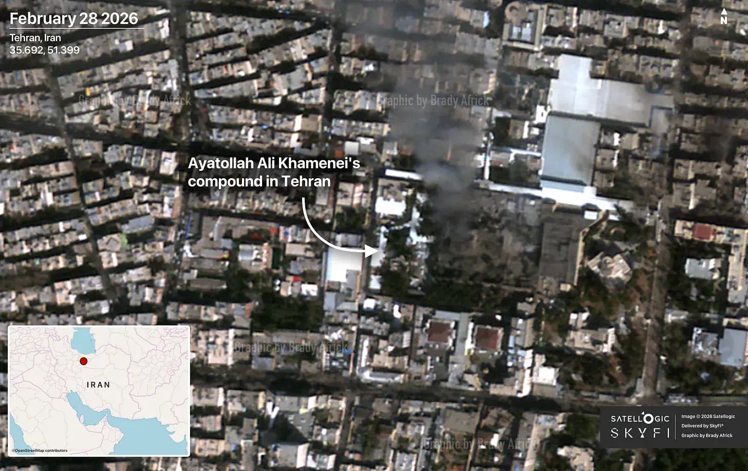
1. Khamenei's Compound Destroyed: Satellogic via SkyFi
OSINT analyst Brady Africk published annotated Satellogic satellite imagery, delivered through SkyFi, showing damage to Supreme Leader Ayatollah Ali Khamenei's compound in Tehran. Khamenei was killed in the opening wave of strikes on February 28, along with roughly 40 other senior Iranian officials, after the CIA tracked his movements to a Saturday morning meeting at the compound. Vantor and Airbus also captured imagery of the compound that appeared across CBS News, NPR, the New York Times, Reuters, and CNN.
The Satellogic image was captured and delivered through SkyFi's platform, the self-service satellite imagery marketplace where anyone can order satellite imagery on demand from 50+ providers, no contract required.
Explore Satellogic imagery and all SkyFi partners
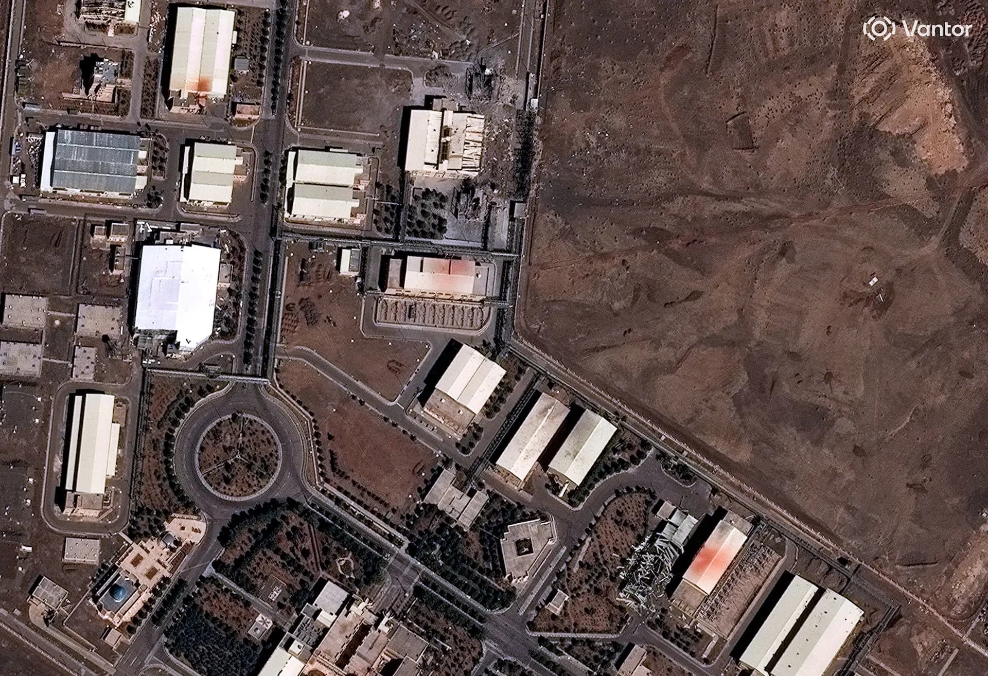
2. Natanz Nuclear Facility Struck: Vantor via Reuters
Vantor satellite imagery captured on March 2 revealed new damage to Iran's Natanz nuclear enrichment facility. The image, published by Reuters, shows destroyed entrance buildings to the underground Fuel Enrichment Plant, one of Iran's three known uranium enrichment facilities. The IAEA confirmed the damage on Tuesday, and the Institute for Science and International Security, led by former UN nuclear inspector David Albright, published its own analysis of the Vantor data a day earlier. Iran had said Natanz was hit on Sunday, but the IAEA initially responded that it had no indication any nuclear site had been struck. It was Vantor's commercial satellite imagery that confirmed the strikes.
Vantor's full archive (20+ years of imagery at resolutions down to 15 cm HD), on-demand tasking, 3D terrain models, and global basemaps are all available through SkyFi with no enterprise contract required.
Access Vantor satellite imagery on demand
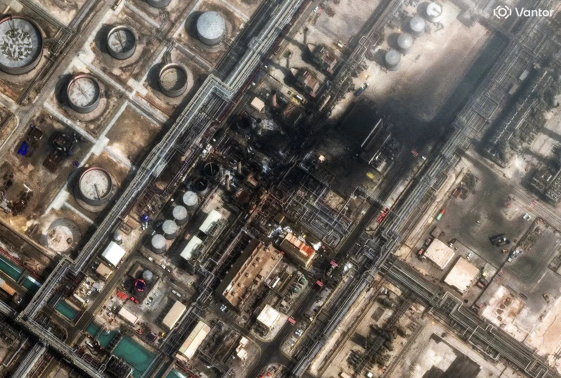
3. Saudi Oil Refinery on Fire: Vantor via Reuters
Vantor imagery published by Reuters captured smoke rising from the Ras Tanura oil refinery in Saudi Arabia on March 2 after an Iranian drone attack. Ras Tanura is one of the world's largest oil export terminals.
This image shows the cascading impact of the conflict beyond Iran's borders. Global shipping has been disrupted, companies have suspended Suez Canal traffic, and Iran's Revolutionary Guards have told ships that passage through the Strait of Hormuz is "not allowed." For energy traders, insurance underwriters, commodity analysts, and supply chain managers, this is the image that makes satellite monitoring operationally urgent. Not just for defense, but for financial services, energy, and insurance workflows.
SkyFi's AIS vessel tracking complements satellite imagery by providing real-time maritime visibility, anomaly detection, and dark-ship tracking for security and compliance missions.
Track global maritime activity with SkyFi AIS

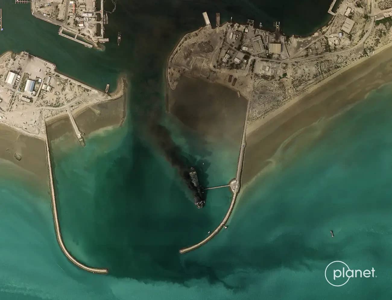
4. Warship Hit at Bandar Abbas: Planet Labs via Business Insider
Planet Labs imagery captured on March 2 and obtained by Business Insider showed a massive plume of smoke rising from the IRINS Makran. Iran's largest warship, a converted oil tanker used as a forward base ship, was burning at Bandar Abbas, the port city adjacent to the Strait of Hormuz.
Planet's SkySat constellation, available for both archive access and new satellite tasking through SkyFi, provided the rapid-revisit capability needed to document a situation changing by the hour.
Task a satellite through SkyFi, no contract required
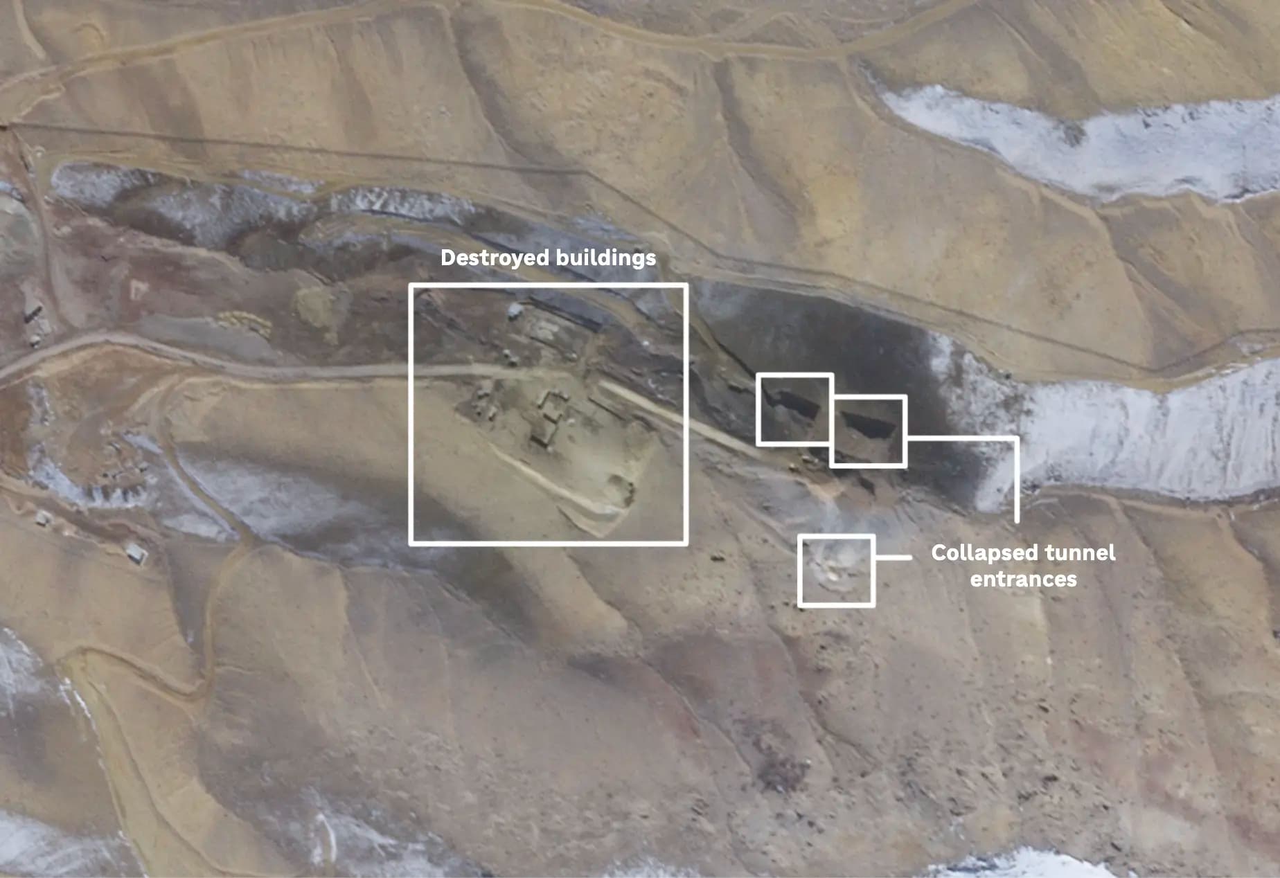
5. Tabriz Missile Base Tunnels Collapsed: Planet Labs via NPR
Planet Labs imagery published by NPR showed collapsed tunnel entrances and destroyed buildings at a missile base in northern Iran. The annotated satellite photo by Connie Hanzhang Jin and Geoff Brumfiel of NPR was captured on March 1 and reveals the scale of damage to one of Iran's most strategically important sites. Iran's most powerful weapons are its long-range missiles, and the Revolutionary Guards had hidden them deep inside mountain tunnels. The satellite imagery confirmed that some of those tunnels were hit in a wave of strikes, caving in the entrances and destroying surrounding infrastructure.
Why This Matters: Satellite Imagery as a Tool for Every Industry
The Iran strikes represent a turning point in how the world consumes information about military conflicts. Traditional war coverage depends on reporters being present, governments releasing information, and sources willing to talk. Commercial satellite imagery bypasses all of those dependencies. It is verifiable, independent, and available to anyone who has access to a satellite tasking platform like SkyFi.
This is not just a defense or intelligence story. The ripple effects of this conflict are being felt across multiple sectors, and satellite imagery is the tool professionals are using to understand them.
Defense and Government. Military planners, allied nations, and government agencies are using satellite imagery for battle damage assessment, force deployment monitoring, and operational planning. SkyFi's ATAK plugin brings live satellite tasking and analytics directly to field operators for real-time situational awareness in defense operations.
Financial Services. The conflict has disrupted global shipping. Companies have suspended traffic through the Suez Canal, airspace closures across the Middle East have stranded hundreds of thousands of travelers, and Iran's Revolutionary Guards have told ships that passage through the Strait of Hormuz is "not allowed." Commodity traders, hedge funds, and financial analysts tracking port activity and oil infrastructure are turning to satellite imagery and AIS vessel tracking for ground truth.
Insurance. Large-scale events generate massive claims activity. Satellite imagery provides the independent verification that underwriters and adjusters need to assess damage across the affected region. SkyFi supports insurance workflows with on-demand imagery ordered for specific sites, no standing contract required.
Energy and Mining. With Iran attempting to close the Strait of Hormuz, through which roughly a fifth of the world's traded oil passes, satellite monitoring of energy infrastructure and supply chain routes has become operationally critical.
Environment and Agriculture. The environmental impact of military operations, including contamination, infrastructure damage affecting agricultural systems, and disruption to water supplies, is often invisible from the ground. SAR imagery can see through smoke and clouds, while NDVI analysis and digital surface models help assess damage that optical sensors alone may miss. SkyFi serves both environmental and agricultural monitoring needs.
Why SkyFi: The Fastest Way to Order Satellite Imagery
The satellite imagery defining global understanding of the Iran conflict comes from Vantor, Planet Labs, Satellogic, and other commercial providers, all available through one platform: SkyFi.
Traditionally, buying satellite imagery from providers like Vantor meant enterprise sales teams, six-figure annual contracts, and multi-week procurement cycles. SkyFi eliminates all of that.
No contracts required. Buy satellite imagery one image at a time with transparent pricing. No minimum spend, no annual commitments, no "request a quote" button.
Task a satellite in minutes. Need new imagery of a specific location? SkyFi's satellite tasking platform lets you order a new capture from your browser, mobile app, or through the SkyFi API, and receive the data directly, including delivery to AWS S3 for enterprise workflows.
The same providers the world's top newsrooms trust. Access Vantor, Planet, Satellogic, Umbra, ICEYE, and 50+ other providers, all in one satellite imagery marketplace. The same constellations powering Reuters, AP, NPR, CBS, and the Washington Post are available to you.
SAR for all-weather visibility. When smoke, clouds, or nighttime conditions obscure optical imagery, Synthetic Aperture Radar (SAR) sees through it. This is a critical capability for real-time monitoring in active conflict zones.
Built-in analytics. Object detection, change detection, NDVI color maps, and digital surface models turn raw satellite data into actionable intelligence without needing a GIS team.
Free open data to start. Not ready to buy? SkyFi offers free open data imagery from partners including Copernicus Sentinel (Multispectral and SAR) and Umbra (SAR data).
SkyFi's Partner Constellation
SkyFi does not operate its own satellites. Instead, it aggregates imagery and analytics from 50+ providers into a single self-service platform, forming the largest virtual constellation of commercial Earth observation assets in the world. The partners most relevant to the Iran strikes coverage:
Vantor (formerly Maxar Intelligence) operates the WorldView constellation, including WorldView Legion, WorldView-3, WorldView-2, and GeoEye-1. It delivers the highest resolution commercial satellite imagery available, down to 30cm and 15 cm HD, with up to 15 daily revisits of any location on Earth and a searchable archive spanning 20+ years. Available on SkyFi for archive search, on-demand tasking, 3D terrain models, and global basemaps.
Planet Labs operates the SkySat constellation, delivering high-frequency optical satellite imagery optimized for rapid-revisit monitoring and change detection. Planet's daily imaging cadence makes it ideal for tracking fast-moving situations where conditions shift by the hour. Available on SkyFi for both archive access and new satellite tasking.
Satellogic operates 30+ satellites in low-Earth orbit, delivering sub-meter multispectral imagery in the 0.7 to 0.99m resolution range with up to 7 daily revisits over select points of interest. Priority tasking allows users to task and receive new imagery within 24 hours. Satellogic's affordable, high-frequency global coverage makes it well suited for change detection, disaster response, and ongoing monitoring of developing situations.
Umbra provides Synthetic Aperture Radar (SAR) satellite imagery, capturing high-resolution images day or night, through clouds, smoke, and adverse weather. SAR is critical for continuous monitoring in conflict zones, disaster response, and any scenario where optical sensors are obscured.
ICEYE US operates the world's largest commercial SAR satellite constellation, delivering radar imagery with rapid revisit times and sub-meter resolution. ICEYE's persistent monitoring capability supports defense, insurance, and disaster response workflows where near-real-time situational awareness is essential.
All accessible through SkyFi. No contracts, no minimum orders, transparent pricing.
Task a satellite or browse archive imagery today, no contract required.
Frequently Asked Questions
How much does satellite imagery cost?
Pricing varies by provider, resolution, and whether you are ordering archive imagery or tasking a new satellite capture. SkyFi offers transparent pricing with no hidden fees, no annual commitments, and no minimum spend. You can purchase a single image or set up recurring tasking for ongoing monitoring, all without a contract.
Can I task a satellite to capture new imagery of a specific location?
Yes. SkyFi's satellite tasking platform lets you task satellites from Vantor, Planet, Satellogic, and other providers through a simple web interface, mobile app, or API. Define your area of interest, select a provider and resolution, and receive the imagery when captured, including direct delivery to AWS S3.
What is SAR imagery and why is it useful in conflict zones?
Synthetic Aperture Radar (SAR) uses radar pulses instead of visible light, meaning it can capture imagery through clouds, smoke, and darkness. In active conflict zones where fires, dust, and weather obscure optical sensors, SAR provides continuous monitoring capability. SkyFi offers SAR imagery through partners like Umbra. Learn more in our SAR Imagery 101 guide.
Do I need a contract to buy satellite imagery?
No. SkyFi was built to eliminate the friction of traditional satellite imagery procurement. There are no contracts, no subscription requirements, and no sales calls. Create a free account and purchase high-resolution satellite imagery immediately.
Kat Tungol is the Product Marketing Manager at SkyFi, with a background in remote sensing and professional training as a licensed geologist. She works at the intersection of geospatial science and product marketing, translating complex Earth observation capabilities into clear, practical value for users.


